
青影 topographic map
Interactive map
Click on the map to display elevation.
About this map
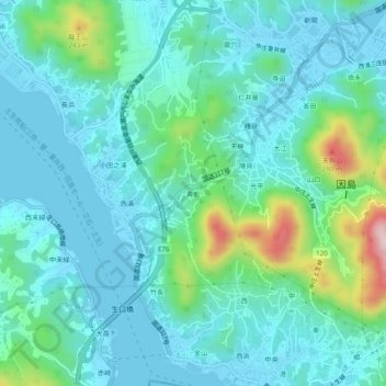
Name: 青影 topographic map, elevation, terrain.
Location: 青影, 尾道市, 広島県, 722-2102, 日本 (34.29607 133.13933 34.33607 133.17933)
Average elevation: 60 m
Minimum elevation: -2 m
Maximum elevation: 316 m
Other topographic maps
Click on a map to view its topography, its elevation and its terrain.