
熊取町 topographic map
Interactive map
Click on the map to display elevation.
About this map
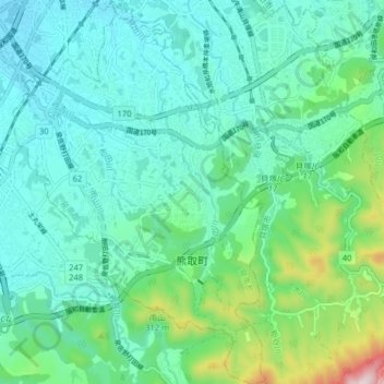
Name: 熊取町 topographic map, elevation, terrain.
Location: 熊取町, 泉南郡, 大阪府, 590-0406, 日本 (34.35484 135.33552 34.42062 135.38838)
Average elevation: 118 m
Minimum elevation: 7 m
Maximum elevation: 555 m
Other topographic maps
Click on a map to view its topography, its elevation and its terrain.