
豊能町 topographic map
Interactive map
Click on the map to display elevation.
About this map
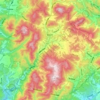
Name: 豊能町 topographic map, elevation, terrain.
Location: 豊能町, 豊能郡, 大阪府, 563-0105, 日本 (34.87340 135.41860 34.94741 135.52583)
Average elevation: 388 m
Minimum elevation: 113 m
Maximum elevation: 667 m
大阪府北西部、京都府と兵庫県の接点に位置する。また北摂山系の中にあり、標高が高いことから隣接する能勢町とともに「大阪の軽井沢」、あるいは寒冷であることを強調して「大阪の北海道」「大阪のシベリア」などと称される。該当する地域(東地区)の標高は400m〜600m程度に位置しており、大阪府中心部より概して3°C程度は気温が低い。また、北摂山系に含まれることから冬季はバスが運休するほどの降雪に見舞われることもあり、温度は氷点下になることもある。一方、西地区一帯では標高200〜300mであり、東地区に比べて降雪量が少ない。
Other topographic maps
Click on a map to view its topography, its elevation and its terrain.