南河内郡 topographic maps
Click on a map to view its topography, its elevation and its terrain.
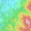
日本 > 大阪府 > 南河内郡
千早赤阪村, 南河内郡, 大阪府, 日本
Average elevation: 437 m
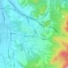
日本 > 大阪府 > 南河内郡
太子町, 南河内郡, 大阪府, 日本
Average elevation: 134 m
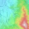
日本 > 大阪府 > 南河内郡
河南町, 南河内郡, 大阪府, 日本
Average elevation: 297 m
