
西成区 topographic map
Interactive map
Click on the map to display elevation.
About this map
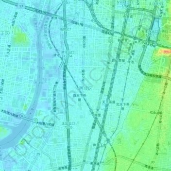
Name: 西成区 topographic map, elevation, terrain.
Location: 西成区, 大阪市, 大阪府, 日本 (34.62164 135.47368 34.65746 135.50860)
Average elevation: 7 m
Minimum elevation: -4 m
Maximum elevation: 35 m
大阪市の南西部に位置する行政区である。区内はおおむね平坦な地形で、大半が住宅街、西部の一部地域が工業地域となっている。鉄道や幹線道路の交通網は主に南北方向に通過し、難波などの大阪市中心部や堺市・大阪府南部方面へとつながっている。新今宮駅付近にはドヤ街のあいりん地区(釜ヶ崎)が所在することでも有名である。また、天王寺にも程近い場所に位置する飛田新地はかつての遊郭だった頃から続く日本最大級の風俗街である。
Other topographic maps
Click on a map to view its topography, its elevation and its terrain.