
三次市 topographic map
Interactive map
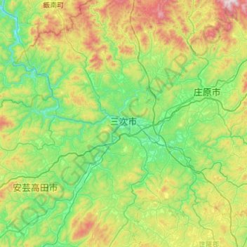
Click on the map to display elevation.
About this map
Name: 三次市 topographic map, elevation, terrain.
Location: 三次市, 広島県, 日本 (34.60522 132.63336 35.00460 133.10966)
Average elevation: 386 m
Minimum elevation: 67 m
Maximum elevation: 1,180 m
三次市の中心部は、中国山地と吉備高原の間に位置する標高150~250mの三次盆地である。中心地の三次町はかつて「五日市」とも呼ばれ、江戸時代に広島藩の支藩、三次藩の城下町だった時期もあり、市街地の旧街道には卯建のある商家が並び、数多くの史跡や忠臣蔵ゆかりの古寺などが存在している。 三次駅のある現在の都心地区は、かつては「十日市町」という別の市町村で、西側に位置する城下町、三次町(五日市)と対応する「市(いち)」として発展してきた。三次町と十日市町とで双子都市圏を形成している。
Other topographic maps
Click on a map to view its topography, its elevation and its terrain.