
Ecuador topographic map
Interactive map
Click on the map to display elevation.
About this map
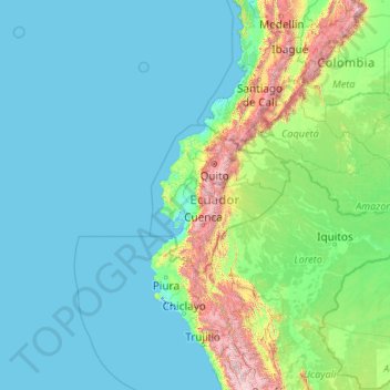
Name: Ecuador topographic map, elevation, terrain.
Location: Ecuador (-5.01593 -92.20724 1.88360 -75.19250)
Average elevation: 366 m
Minimum elevation: -3 m
Maximum elevation: 5,762 m
There is great variety in the climate, largely determined by altitude. It is mild year-round in the mountain valleys, with a humid subtropical climate in coastal areas and rainforest in lowlands. The Pacific coastal area has a tropical climate with a severe rainy season. The climate in the Andean highlands is temperate and relatively dry, and the Amazon basin on the eastern side of the mountains shares the climate of other rainforest zones.
Other topographic maps
Click on a map to view its topography, its elevation and its terrain.
Saint Croix
United States of America (USVI Saint Croix) > United States Virgin Islands
Saint Croix, Saint Croix District, United States Virgin Islands, United States of America (USVI Saint Croix)
Average elevation: 11 m
Isla Plaza Sur
Ecuador > Galápagos > Cantón Santa Cruz
Isla Plaza Sur, Parroquia Bella Vista, Cantón Santa Cruz, Galápagos, Ecuador
Average elevation: 5 m
Puerto Ayora
Ecuador > Galápagos > Cantón Santa Cruz
Puerto Ayora, Parroquia Bella Vista, Cantón Santa Cruz, Galápagos, Ecuador
Average elevation: 28 m
Isla La Isabela
Isla La Isabela, Bolivar State, Venezuela
Average elevation: 9 m
Hyderabad
India > Telangana > Bahadurpura mandal
Hyderabad, Bahadurpura mandal, Hyderabad District, Telangana, India
Average elevation: 549 m
Blaenavon
United Kingdom > Wales > Torfaen
Blaenavon, Torfaen, Wales, NP4 9EJ, United Kingdom
Average elevation: 383 m
Lismore City Council
Lismore City Council, New South Wales, 2480, Australia
Average elevation: 83 m
Victoria Falls
Zambia > Southern Province > Livingstone
Victoria Falls, Livingstone, Livingstone District, Southern Province, Zambia
Average elevation: 875 m
Tegernsee
Germany > Bavaria > Landkreis Miesbach
Tegernsee, Landkreis Miesbach, Bavaria, 83684, Germany
Average elevation: 858 m
Oborci
Bosnia and Herzegovina > Federation of Bosnia and Herzegovina
Oborci, Donji Vakuf Municipality, Central Bosnia Canton, Federation of Bosnia and Herzegovina, 70220, Bosnia and Herzegovina
Average elevation: 807 m
Silver Bay
Canada > Manitoba > Division No. 19 > Unorganized Division No. 19
Silver Bay, Unorganized Division No. 19, Division No. 19, Manitoba, Canada
Average elevation: 248 m
Samfya
Samfya, Samfya District, Luapula Province, Zambia
Average elevation: 1,181 m
Gornji Vakuf-Uskoplje
Bosnia and Herzegovina > Federation of Bosnia and Herzegovina
Gornji Vakuf-Uskoplje, Gornji Vakuf-Uskoplje municipality, Central Bosnia Canton, Federation of Bosnia and Herzegovina, 70240, Bosnia and Herzegovina
Average elevation: 869 m
Donji Vakuf
Bosnia and Herzegovina > Federation of Bosnia and Herzegovina
Donji Vakuf, Donji Vakuf Municipality, Central Bosnia Canton, Federation of Bosnia and Herzegovina, 70220, Bosnia and Herzegovina
Average elevation: 694 m
Beer Lake
Canada > Ontario > Haliburton County > Minden Hills
Beer Lake, Minden Hills, Haliburton County, Central Ontario, Ontario, Canada
Average elevation: 341 m
Silver Bay
United States > Minnesota > Lake County
Silver Bay, Lake County, Minnesota, United States
Average elevation: 247 m
Al Azhar Park
Al Azhar Park, El-Darb El-Ahmar, Cairo, Egypt
Average elevation: 53 m
Walkersville
United States > Maryland > Frederick County
Walkersville, Frederick County, Maryland, 21793, United States
Average elevation: 99 m
Royal Borough of Greenwich
United Kingdom > England > London
Royal Borough of Greenwich, London, Greater London, England, United Kingdom
Average elevation: 32 m
Rangiroa
France > French Polynesia > Rangiroa
Rangiroa, Tuamotu-Gambier, French Polynesia, 98775, France
Average elevation: 0 m
Gwembe
Gwembe, Gwembe District, Southern Province, Zambia
Average elevation: 1,182 m
Niseko
Niseko, Abuta County, Shiribeshi Subprefecture, Hokkaido Prefecture, Japan
Average elevation: 339 m
Hawthorne
United States > Florida > Lee County > Bonita Springs
Hawthorne, Bonita Springs, Lee County, Florida, 34135, United States
Average elevation: 5 m
Big Beaver
United States > Pennsylvania > Beaver County
Big Beaver, Beaver County, Pennsylvania, 16141, United States
Average elevation: 324 m
Kondoa
Kondoa, Kondoa Town, Dodoma Region, Central Zone, Tanzania
Average elevation: 1,386 m
Burke
United States > Virginia > Fairfax County
Burke, Fairfax County, Virginia, 22015, United States
Average elevation: 97 m
Dodoma
Dodoma, Dodoma City, Dodoma Region, Central Zone, Tanzania
Average elevation: 1,144 m
Kazungula District
Kazungula District, Southern Province, Zambia
Average elevation: 1,069 m
Los Altos Hills
United States > California > Santa Clara County
Los Altos Hills, Santa Clara County, California, United States
Average elevation: 146 m
Kasenseli Village
Zambia > North-Western Province
Kasenseli Village, Mwinilunga District, North-Western Province, Zambia
Average elevation: 1,437 m
Kanjimana
Zambia > North-Western Province
Kanjimana, Ikelenge District, North-Western Province, Zambia
Average elevation: 1,279 m
Falaj
Oman > Muscat Governorate > Muscat
Falaj, Muscat, Muscat Governorate, 112, Oman
Average elevation: 194 m
Rufunsa District
Rufunsa District, Lusaka Province, Zambia
Average elevation: 796 m