
Thank you for supporting this site ❤️
Make a donation
Make a donation
Lumwana topographic map
Click on the map to display elevation.
Thank you for supporting this site ❤️
Make a donation
Make a donation
About this map
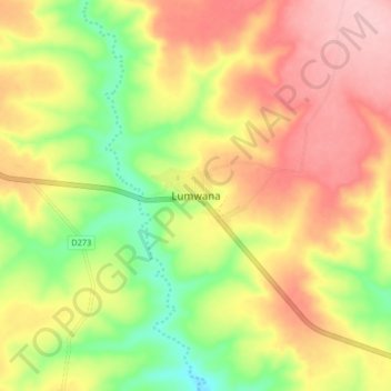
Name: Lumwana topographic map, elevation, terrain.
Location: Lumwana, Mwinilunga District, North-Western Province, Zambia (-11.86500 25.09758 -11.78500 25.17758)
Average elevation: 1,457 m
Minimum elevation: 1,373 m
Maximum elevation: 1,532 m
Thank you for supporting this site ❤️
Make a donation
Make a donation
Other topographic maps
Click on a map to view its topography, its elevation and its terrain.