
Thank you for supporting this site ❤️
Make a donation
Make a donation
Mazabuka topographic map
Click on the map to display elevation.
Thank you for supporting this site ❤️
Make a donation
Make a donation
About this map
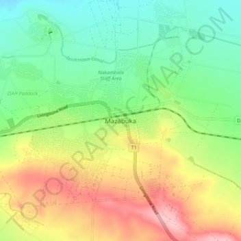
Name: Mazabuka topographic map, elevation, terrain.
Location: Mazabuka, Mazabuka District, Southern Province, Zambia (-15.89848 27.72131 -15.81848 27.80131)
Average elevation: 1,059 m
Minimum elevation: 996 m
Maximum elevation: 1,152 m
Thank you for supporting this site ❤️
Make a donation
Make a donation
Other topographic maps
Click on a map to view its topography, its elevation and its terrain.