
Kafue topographic map
Interactive map
Click on the map to display elevation.
Kafue
The Kafue River rises at an elevation of 1350 m on the relatively flat plateau just south the border between Zambia and the Democratic Republic of the Congo 120 km north-west of Chingola in the Copperbelt Province. The source of the Kafue River is in the North-western Province of Zambia. The area is Miombo woodland on the Congo-Zambezi watershed, with many branching dambos lying 10 to 20 m lower than the highest ground, producing a very gently undulating topography. The river starts as a trickle from the marshy dambos (the Munyanshi Swamp is a tributary) and with little slope to speed up river flow, it meanders south-eastwards sluggishly and within 50 km has the character of a mature river. The area receives about 1200 mm of rain in the rainy season, and the river's channel soon reaches 100 m wide with a floodplain of fluvial dambos 1–2 km wide.
About this map
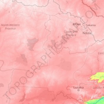
Name: Kafue topographic map, elevation, terrain.
Location: Kafue, Zambia (-15.97010 25.91278 -11.65303 28.91739)
Average elevation: 1,177 m
Minimum elevation: 350 m
Maximum elevation: 1,597 m
Other topographic maps
Click on a map to view its topography, its elevation and its terrain.
Choma
Choma lies on the Lusaka–Livingstone Road, approximately 292 kilometres (181 mi) south-west of Lusaka, the national capital and largest city in Zambia. This is approximately 194 kilometres (121 mi), by road, northeast of Livingstone, the largest city in Zambia's Southern Province. The geographical…
Average elevation: 1,310 m
Chadiza
Chadiza is a town in the Eastern Province of Zambia. Its headquarters are located in Chadiza District. It lies 35 km south of the Great East Road and about 80 km south-south-west of Chipata, on a plateau (elevation 1050 m) studded by isolated rocky hills, between the middle Luangwa valley and the Zambezi. It…
Average elevation: 1,055 m