
Lusaka Province topographic map
Interactive map
Click on the map to display elevation.
Lusaka Province
Lusaka Province is bordered along Zimbabwe along Lower Zambezi National Park in the south, Central Province in the north, Southern Province in the southwest and Eastern Province in the north east. The general topography of the province is characterized by uplifted plantation surfaces. The general elevation of the nation as a whole is tended towards West to East from the Kalahari Basin. The level of land falls from the upper Congo towards the Zambezi depression in the South forming a plateau.
About this map
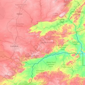
Name: Lusaka Province topographic map, elevation, terrain.
Location: Lusaka Province, Zambia (-15.97010 27.76911 -14.64314 30.42080)
Average elevation: 866 m
Minimum elevation: 325 m
Maximum elevation: 1,604 m
Other topographic maps
Click on a map to view its topography, its elevation and its terrain.
Choma
Choma lies on the Lusaka–Livingstone Road, approximately 292 kilometres (181 mi) south-west of Lusaka, the national capital and largest city in Zambia. This is approximately 194 kilometres (121 mi), by road, northeast of Livingstone, the largest city in Zambia's Southern Province. The geographical…
Average elevation: 1,310 m
Chadiza
Chadiza is a town in the Eastern Province of Zambia. Its headquarters are located in Chadiza District. It lies 35 km south of the Great East Road and about 80 km south-south-west of Chipata, on a plateau (elevation 1050 m) studded by isolated rocky hills, between the middle Luangwa valley and the Zambezi. It…
Average elevation: 1,055 m