
Make a donation
Central Province topographic map
Click on the map to display elevation.
Make a donation
About this map
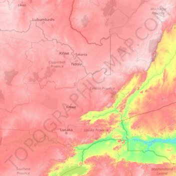
Name: Central Province topographic map, elevation, terrain.
Location: Central Province, Zambia (-15.75348 25.31369 -12.02942 31.43974)
Average elevation: 1,059 m
Minimum elevation: 314 m
Maximum elevation: 1,802 m
Make a donation
Other topographic maps
Click on a map to view its topography, its elevation and its terrain.
Choma
Choma lies on the Lusaka–Livingstone Road, approximately 292 kilometres (181 mi) south-west of Lusaka, the national capital and largest city in Zambia. This is approximately 194 kilometres (121 mi), by road, northeast of Livingstone, the largest city in Zambia's Southern Province. The geographical…
Average elevation: 1,310 m
Make a donation
Chadiza
Chadiza is a town in the Eastern Province of Zambia. Its headquarters are located in Chadiza District. It lies 35 km south of the Great East Road and about 80 km south-south-west of Chipata, on a plateau (elevation 1050 m) studded by isolated rocky hills, between the middle Luangwa valley and the Zambezi. It…
Average elevation: 1,055 m
Make a donation
Make a donation
Make a donation
Make a donation