
California topographic map
Interactive map
Click on the map to display elevation.
About this map
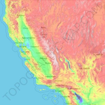
Name: California topographic map, elevation, terrain.
Location: California, United States (32.52952 -124.48200 42.00950 -114.13078)
Average elevation: 929 m
Minimum elevation: -82 m
Maximum elevation: 4,095 m
California's mountains produce rain shadows on the eastern side, creating extensive deserts. The higher elevation deserts of eastern California have hot summers and cold winters, while the low deserts east of the Southern California mountains have hot summers and nearly frostless mild winters. Death Valley, a desert with large expanses below sea level, is considered the hottest location in the world; the highest temperature in the world, 134 °F (56.7 °C), was recorded there on July 10, 1913. The lowest temperature in California was −45 °F (−43 °C) on January 20, 1937, in Boca.
Other topographic maps
Click on a map to view its topography, its elevation and its terrain.
Silver Bay
United States > Minnesota > Lake County
Silver Bay, Lake County, Minnesota, United States
Average elevation: 247 m
Walkersville
United States > Maryland > Frederick County
Walkersville, Frederick County, Maryland, 21793, United States
Average elevation: 99 m
Hawthorne
United States > Florida > Lee County > Bonita Springs
Hawthorne, Bonita Springs, Lee County, Florida, 34135, United States
Average elevation: 5 m
Big Beaver
United States > Pennsylvania > Beaver County
Big Beaver, Beaver County, Pennsylvania, 16141, United States
Average elevation: 324 m
Burke
United States > Virginia > Fairfax County
Burke, Fairfax County, Virginia, 22015, United States
Average elevation: 97 m
Los Altos Hills
United States > California > Santa Clara County
Los Altos Hills, Santa Clara County, California, United States
Average elevation: 146 m
Rattan
United States > Oklahoma > Pushmataha County
Rattan, Pushmataha County, Oklahoma, 74562, United States
Average elevation: 153 m
Newell Station
United States > Tennessee > Sevier County
Newell Station, Seymour, Sevier County, East Tennessee, Tennessee, 37865, United States
Average elevation: 323 m
Town of Manchester
United States > New York > Ontario County
Town of Manchester, Ontario County, New York, United States
Average elevation: 180 m
Harlingen
United States > Texas > Cameron County
Harlingen, Cameron County, Texas, 78550, United States
Average elevation: 14 m
Town of Bangor
United States > New York > Franklin County
Town of Bangor, Franklin County, New York, 12966, United States
Average elevation: 209 m
Wellesley
United States > Massachusetts > Norfolk County
Wellesley, Norfolk County, Massachusetts, United States
Average elevation: 52 m
Down Under Tank
United States > Arizona > Santa Cruz County
Down Under Tank, Santa Cruz County, Arizona, United States
Average elevation: 1,587 m
Inglewood
United States > California > Los Angeles County
Inglewood, Los Angeles County, California, United States
Average elevation: 39 m
Culver City
United States > California > Los Angeles County
Culver City, Los Angeles County, California, United States
Average elevation: 40 m
San Miguel County
San Miguel County, Colorado, United States
Average elevation: 2,357 m
Alba
United States > Missouri > Jasper County
Alba, Jasper County, Missouri, 64830, United States
Average elevation: 291 m
Saratoga
United States > Wyoming > Carbon County
Saratoga, Carbon County, Wyoming, 82331, United States
Average elevation: 2,086 m
Rotan
United States > Texas > Fisher County
Rotan, Fisher County, Texas, 79546, United States
Average elevation: 598 m
Chama
United States > New Mexico > Rio Arriba County
Chama, Rio Arriba County, New Mexico, 87520, United States
Average elevation: 2,435 m
Cascades
United States > Virginia > Loudoun County > Cascades
Cascades, Loudoun County, Virginia, 20165, United States
Average elevation: 81 m
Village of Black River
United States > New York > Jefferson County
Village of Black River, Town of Le Ray, Jefferson County, New York, United States
Average elevation: 193 m
United States Virgin Islands
United States Virgin Islands, United States
Average elevation: 4 m
Clearwater Beach
United States > Florida > Pinellas County > Clearwater
Clearwater Beach, Clearwater, Pinellas County, Florida, 33767, United States
Average elevation: 1 m
Sorrento
United States > Florida > Lake County > Sorrento
Sorrento, Lake County, Florida, United States
Average elevation: 27 m
Sarasota
United States > Florida > Sarasota County > Sarasota
Sarasota, Sarasota County, Florida, United States
Average elevation: 7 m
North Bend
United States > Washington > King County
North Bend, King County, Washington, United States
Average elevation: 160 m
The Vistas
United States > Texas > Ector County > Odessa
The Vistas, Odessa, Ector County, Texas, 79765, United States
Average elevation: 882 m
Irvine
United States > California > Orange County
Irvine, Orange County, CAL Fire Southern Region, California, United States
Average elevation: 66 m