
Make a donation
Illinois topographic map
Click on the map to display elevation.
Make a donation
Illinois
Though Illinois lies entirely in the Interior Plains, it does have some minor variation in its elevation. In extreme northwestern Illinois, the Driftless Area, a region of unglaciated and therefore higher and more rugged topography, occupies a small part of the state. Southern Illinois includes the hilly areas around the Shawnee National Forest.
Make a donation
About this map
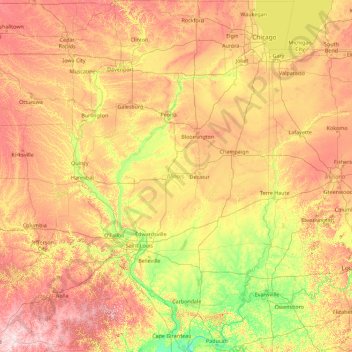
Name: Illinois topographic map, elevation, terrain.
Location: Illinois, United States (36.97013 -91.51305 42.50837 -87.01992)
Average elevation: 213 m
Minimum elevation: 91 m
Maximum elevation: 528 m
Make a donation
Other topographic maps
Click on a map to view its topography, its elevation and its terrain.
Make a donation
Fern Glen
United States > Pennsylvania > Luzerne County > Black Creek Township
Average elevation: 391 m
Make a donation
Trachsville
United States > Pennsylvania > Carbon County > Towamensing Township
Average elevation: 256 m
Make a donation
Make a donation
Make a donation
Cleveland
United States > Ohio > Cuyahoga County > Cleveland
The land rises quickly from the lake shore elevation of 569 feet. Public Square, less than one mile (1.6 km) inland, sits at an elevation of 650 feet (198 m), and Hopkins Airport, 5 miles (8 km) inland from the lake, is at an elevation of 791 feet (241 m).
Average elevation: 219 m
Make a donation
Glen Canyon Dam
United States > Arizona > Coconino County
The Bureau of Reclamation favored the Echo Park site over Glen Canyon, because its narrow canyons and high elevation (more than 5,000 feet (1,500 m), as compared to 3,700 feet (1,100 m) at Glen Canyon) would lead to less evaporation. It said that building Echo Park Dam and a "low" Glen Canyon Dam would save…
Average elevation: 1,171 m
Miami
United States > Florida > Miami-Dade County
Miami and its suburbs are located on a broad plain between the Everglades to the west and Biscayne Bay to the east, which extends from Lake Okeechobee southward to Florida Bay. The elevation of the area averages at around 6 ft (1.8 m)[39] above sea level in most neighborhoods, especially near the coast. The…
Average elevation: 4 m
Make a donation