
Nebraska topographic map
Interactive map
Click on the map to display elevation.
Nebraska
Nebraska is composed of two major land regions: the Dissected Till Plains and the Great Plains. The easternmost portion of the state was scoured by Ice Age glaciers; the Dissected Till Plains were left after the glaciers retreated. The Dissected Till Plains is a region of gently rolling hills; Omaha and Lincoln are in this region. The Great Plains occupy most of western Nebraska, with the region consisting of several smaller, diverse land regions, including the Sandhills, the Pine Ridge, the Rainwater Basin, the High Plains and the Wildcat Hills. Panorama Point, at 5,424 feet (1,653 m), is Nebraska's highest point; though despite its name and elevation, it is a relatively low rise near the Colorado and Wyoming borders. A past tourism slogan for the state of Nebraska was "Where the West Begins" (it has since been changed to "Honestly, it's not for everyone"). Locations given for the beginning of the "West" in Nebraska include the Missouri River, the intersection of 13th and O Streets in Lincoln (where it is marked by a red brick star), the 100th meridian, and Chimney Rock.
About this map
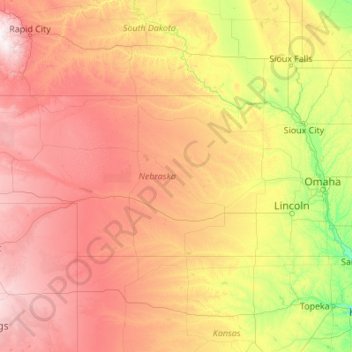
Name: Nebraska topographic map, elevation, terrain.
Location: Nebraska, United States (39.99998 -104.05351 43.00148 -95.30805)
Average elevation: 747 m
Minimum elevation: 255 m
Maximum elevation: 2,159 m
Other topographic maps
Click on a map to view its topography, its elevation and its terrain.
Fern Glen
United States > Pennsylvania > Luzerne County > Black Creek Township
Average elevation: 391 m
Trachsville
United States > Pennsylvania > Carbon County > Towamensing Township
Average elevation: 256 m
Miami
United States > Florida > Miami-Dade County
Miami and its suburbs are located on a broad plain between the Everglades to the west and Biscayne Bay to the east, which extends from Lake Okeechobee southward to Florida Bay. The elevation of the area averages at around 6 ft (1.8 m)[39] above sea level in most neighborhoods, especially near the coast. The…
Average elevation: 4 m
Cleveland
United States > Ohio > Cuyahoga County > Cleveland
The land rises quickly from the lake shore elevation of 569 feet. Public Square, less than one mile (1.6 km) inland, sits at an elevation of 650 feet (198 m), and Hopkins Airport, 5 miles (8 km) inland from the lake, is at an elevation of 791 feet (241 m).
Average elevation: 219 m
Glen Canyon Dam
United States > Arizona > Coconino County
The Bureau of Reclamation favored the Echo Park site over Glen Canyon, because its narrow canyons and high elevation (more than 5,000 feet (1,500 m), as compared to 3,700 feet (1,100 m) at Glen Canyon) would lead to less evaporation. It said that building Echo Park Dam and a "low" Glen Canyon Dam would save…
Average elevation: 1,171 m