
袖平山 topographic map
Interactive map
Click on the map to display elevation.
About this map
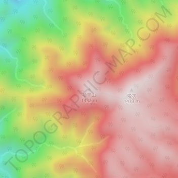
Name: 袖平山 topographic map, elevation, terrain.
Location: 袖平山, 相模原市, 神奈川県, 日本 (35.51078 139.12614 35.51088 139.12624)
Average elevation: 1,076 m
Minimum elevation: 542 m
Maximum elevation: 1,421 m
袖平山(そでひらやま)とは、丹沢山地北部、丹沢主脈(実際の主脈縦走路からは少し離れている)にある標高1,432mの山である。神奈川県相模原市内に位置し、丹沢大山国定公園に属する。「袖平」とも呼ばれる。
Other topographic maps
Click on a map to view its topography, its elevation and its terrain.