
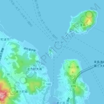
来島 topographic map
Interactive map
Click on the map to display elevation.
About this map
Name: 来島 topographic map, elevation, terrain.
Location: 来島, 今治市, 愛媛県, 日本 (34.11645 132.96829 34.11998 132.97112)
Average elevation: 11 m
Minimum elevation: -20 m
Maximum elevation: 134 m
来島(くるしま)は、愛媛県今治市の来島海峡の西側、波止浜湾の入り口、四国から沖合い240mに位置する有人島である。芸予諸島の一部(来島群島)をなし、面積0.04km2。島の中央に標高47mの小山があり、かつては来島城もあった。島の南東に来島漁港と集落がある。来島海峡は潮流が速く、潮向も複雑なことからきた「狂う潮」が訛り、「くるしま」となったといわれている。住所表記上は、近傍の小島(おしま)も含まれる。
Other topographic maps
Click on a map to view its topography, its elevation and its terrain.