
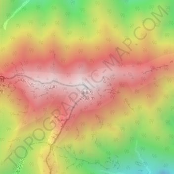
蓮華岳 topographic map
Interactive map
Click on the map to display elevation.
About this map
Name: 蓮華岳 topographic map, elevation, terrain.
Location: 蓮華岳, 大町市, 長野県, 日本 (36.53572 137.71049 36.53582 137.71059)
Average elevation: 2,284 m
Minimum elevation: 1,597 m
Maximum elevation: 2,792 m
蓮華岳(れんげだけ)は、飛騨山脈北部 、富山県中新川郡立山町と長野県大町市とにまたがる標高2,799 mの山。日本で66番目に高い山。針ノ木峠を挟んで針ノ木岳の東側に対峙している。
Other topographic maps
Click on a map to view its topography, its elevation and its terrain.