
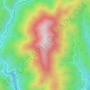
小五郎山 topographic map
Interactive map
Click on the map to display elevation.
About this map
Name: 小五郎山 topographic map, elevation, terrain.
Location: 小五郎山, 岩国市, 山口県, 日本 (34.41671 132.00849 34.41681 132.00859)
Average elevation: 712 m
Minimum elevation: 379 m
Maximum elevation: 1,141 m
小五郎山(こごろうさん)は、山口県岩国市錦町宇佐郷にある標高1,161.7mの山である。中国山地西部の冠山山地に属しているこの山は西中国山地の雄として、その名を知られ、中国百名山にも指定されている。
Other topographic maps
Click on a map to view its topography, its elevation and its terrain.