
仙丈ヶ岳 topographic map
Interactive map
Click on the map to display elevation.
About this map
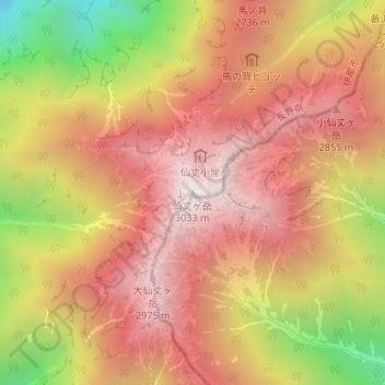
Name: 仙丈ヶ岳 topographic map, elevation, terrain.
Location: 仙丈ヶ岳, 伊那市, 長野県, 日本 (35.72003 138.18355 35.72013 138.18365)
Average elevation: 2,543 m
Minimum elevation: 1,780 m
Maximum elevation: 3,019 m
仙丈ヶ岳または仙丈岳(せんじょうがたけ・せんじょうだけ)は、長野県伊那市と山梨県南アルプス市にまたがる南アルプス国立公園内の赤石山脈の北部にある標高3,033 mの山である。
Other topographic maps
Click on a map to view its topography, its elevation and its terrain.