
Mozambique topographic map
Interactive map
Click on the map to display elevation.
Mozambique
The country is divided into two topographical regions by the Zambezi River. To the north of the Zambezi River, the narrow coastal strip gives way to inland hills and low plateaus. Rugged highlands are further west; they include the Niassa highlands, Namuli or Shire highlands, Angonia highlands, Tete highlands and the Makonde plateau, covered with miombo woodlands. To the south of the Zambezi River, the lowlands are broader with the Mashonaland plateau and Lebombo Mountains located in the deep south.
About this map
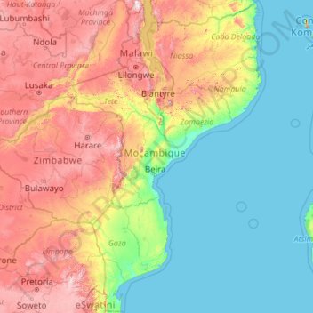
Name: Mozambique topographic map, elevation, terrain.
Location: Mozambique (-26.92094 30.21217 -10.32521 41.05459)
Average elevation: 485 m
Minimum elevation: 0 m
Maximum elevation: 2,522 m
Other topographic maps
Click on a map to view its topography, its elevation and its terrain.
Vienna
Vienna is located in northeastern Austria, at the easternmost extension of the Alps in the Vienna Basin. The earliest settlement, at the location of today's inner city, was south of the meandering Danube while the city now spans both sides of the river. Elevation ranges from 151 to 542 m (495 to 1,778 ft). The…
Average elevation: 231 m
Dordrecht
South Africa > Eastern Cape > Chris Hani District Municipality > Emalahleni Local Municipality
Average elevation: 1,678 m
Shirakawa
Shirakawa is a mountain village located in far northern Gifu Prefecture, bordering Ishikawa Prefecture and Toyama Prefecture on the Ryōhaku Mountains. Mount Hakusan is the highest elevation at 2,172 metres (7,126 ft). The village's area is 95.7% mountainous forests, and its steep places are characteristic. In…
Average elevation: 667 m
Prenj
Bosnia and Herzegovina > Federation of Bosnia and Herzegovina > Town of Stolac
Average elevation: 169 m
Ta'izz
Taiz (Arabic: تَعِزّ, romanized: Taʿizz) is a city in southwestern Yemen. It is located in the Yemeni highlands, near the port city of Mocha on the Red Sea, at an elevation of about 1,400 metres (4,600 ft) above sea level. It is the capital of Taiz Governorate. As of 2023, the city has an estimated…
Average elevation: 1,416 m
قرين أبو البول
Qurain Abu al-Bawl (also Gurain al Balbul, Gurain al Bâlbûl, Qurain Abul Bul, Qurayn Aba al Bawl, Qurayn Abā al Bawl, Tuwayyir al Hamir) is the highest point of Qatar, with an altitude of 103 metres (338 ft). It is located south of the peninsula near the border to Saudi Arabia.
Average elevation: 65 m
Athens
Greece > Attica > Regional Unit of Central Athens
The southern section of the Athens metropolitan area (i.e., Elliniko, Athens Riviera) lies in the transitional zone between Mediterranean (Csa) and hot semi-arid climate (BSh), with its port-city of Piraeus being the most extreme example, receiving just 331.9 millimetres (13.07 in) per year. The areas to the…
Average elevation: 168 m
Mbala
The town is at the edge of the plateau covering most of Zambia, at an elevation of 1670 m, about 900 m higher than Lake Tanganyika, which comes within 22 km (straight-line distance). The escarpment above the lake is the end of the Albertine Rift, the western branch of the East Africa Rift, and the Mbala area…
Average elevation: 1,632 m
Adamawa Plateau
Cameroon > Adamawa > Vina > Nyambaka
The Adamawa Plateau is the source of many waterways, including the Benue River. The average elevation is about 3,300 feet (1,000 meters), but elevations can reach as high as 8,700 feet (2,700 meters). It is important for its deposits of bauxite. The vegetation is mostly savanna. The endangered toad…
Average elevation: 1,127 m
Plitra
Greece > Peloponnese, Western Greece and the Ionian > Laconia Regional Unit
Average elevation: 52 m
Awka
Nigeria > Anambra State > Awka South
Awka lies below 300 metres above sea in a valley on the plains of the Mamu River. Two ridges or cuestas, both lying in a north–south direction, form the major topographical features of the area. The ridges reach the highest point at Agulu just outside the Capital Territory. About six kilometers east of this,…
Average elevation: 90 m
Thuvakudi
India > Tamil Nadu > Thiruverumbur
Thuvakudi is located at 10°45′23″N 78°48′04″E / 10.756389°N 78.801111°E / 10.756389; 78.801111. The average elevation is 88 metres (289 ft). The topology of Thuvakudi is almost flat with a few isolated hillocks rising above the surface. The city spread over an area of 14.371 square…
Average elevation: 78 m
Mamelodi
South Africa > Gauteng > City of Tshwane Metropolitan Municipality
Average elevation: 1,319 m
Africa
Average elevation: 462 m
Kumbakonam
India > Tamil Nadu > Kumbakonam
Kumbakonam is located at 10°58′N 79°25′E / 10.97°N 79.42°E / 10.97; 79.42. It is situated 273 km (170 mi) south of Chennai, 96 km (60 mi) east of Tiruchirappalli, about 40 km (25 mi) north-east of Thanjavur., and about 35 km (22 mi) south-west of Mayiladuthurai. It lies in the region called…
Average elevation: 27 m
Glasgow
United Kingdom > Scotland > Glasgow City
Glasgow itself was reputed to have been founded by the Christian missionary Saint Mungo in the 6th century. He established a church on the Molendinar Burn, where the present Glasgow Cathedral stands, and in the following years Glasgow became a religious centre. Glasgow grew over the following centuries as part…
Average elevation: 128 m
K2
Pakistan > Gilgit-Baltistan > Shigar District
Also occasionally known as Mount Godwin-Austen, other nicknames for K2 are The King of Mountains and The Mountaineers' Mountain, as well as The Mountain of Mountains after prominent Italian climber Reinhold Messner titled his book about K2 the same. Although the summit of Everest is at a higher altitude, K2 is…
Average elevation: 7,474 m
Halifax
United Kingdom > England > Calderdale
Topographically, Halifax is located in the south-eastern foothills of the moorland region called the South Pennines. Halifax is situated about 4 miles (6 km) from the M62 motorway, close to Bradford and Huddersfield. The A641 road links the town with Brighouse, Bradford and Huddersfield. The Hebble Brook joins…
Average elevation: 196 m
Windsor Castle
United Kingdom > England > Royal Borough of Windsor and Maidenhead > Windsor > Clewer Village
Average elevation: 23 m
Le Crêt
Switzerland > Vaud > District de la Riviera-Pays-d’Enhaut > Rougemont
Average elevation: 1,229 m
Nakonde
This is approximately 350 kilometres (217 mi), by road, north of Mpika, the largest city in the province. The geographical coordinates of the town are: 09°19'38.0"S, 32°45'30.0"E (Latitude:-9.327222; Longitude:32.758333). The average elevation of Nakonde is about 1,306 metres (4,285 ft), above sea level.…
Average elevation: 1,613 m
Asia
Average elevation: 563 m
Seto Inland Sea
Average elevation: 5 m
Mount Everest
Nepal > Koshi Province > Solukhumbu
Mount Everest, known officially and locally as Sagarmatha in Nepal or Qomolangma in Tibet, is Earth's highest mountain above sea level, located in the Mahalangur Himal sub-range of the Himalayas. The China–Nepal border runs across its summit point. Its elevation (snow height) of 8,848.86 m (29,031 ft 8+1⁄2…
Average elevation: 7,847 m
Harrogate
United Kingdom > England > North Yorkshire
Harrogate is situated on the edge of the Yorkshire Dales, with the Vale of York to the east and the upland Yorkshire Dales to the west and north-west. It has a dry and mild climate, typical of places in the rain shadow of the Pennines. It is on the A59 from Skipton to York. At an altitude of between 100 and…
Average elevation: 106 m
Randburg
South Africa > Gauteng > City of Johannesburg Metropolitan Municipality
Average elevation: 1,567 m
Medina
Saudi Arabia > Medina Province
Medina is located in the Hejaz region which is a 200 km (120 mi) wide strip between the Nafud desert and the Red Sea. Located approximately 720 km (450 mi) northwest of Riyadh which is at the center of the Saudi desert, the city is 250 km (160 mi) away from the west coast of Saudi Arabia and at an elevation of…
Average elevation: 692 m