
藤原台北町1丁目 topographic map
Interactive map
Click on the map to display elevation.
About this map
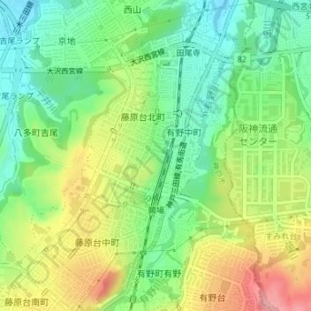
Name: 藤原台北町1丁目 topographic map, elevation, terrain.
Location: 藤原台北町1丁目, 藤原台北町, 北区, 神戸市, 兵庫県, 日本 (34.82227 135.22007 34.82852 135.22462)
Average elevation: 237 m
Minimum elevation: 187 m
Maximum elevation: 309 m
Other topographic maps
Click on a map to view its topography, its elevation and its terrain.