
Vietnam topographic map
Interactive map
Click on the map to display elevation.
Vietnam
Due to differences in latitude and the marked variety in topographical relief, Vietnam's climate tends to vary considerably for each region. Vietnam is a country located in the tropics, however Northern Vietnam, including Hanoi, is considered a subtropical region by Köppen climate classification and has times to be influenced by cold waves from the Northeast. Cold waves also can influence northern part of Central Vietnam. During the winter or dry season, extending roughly from November to April, the monsoon winds usually blow from the northeast along the Chinese coast and across the Gulf of Tonkin, picking up considerable moisture. The average annual temperature is generally higher in the plains than in the mountains, especially in southern Vietnam compared to the north. Temperatures vary less in the southern plains around Ho Chi Minh City and the Mekong Delta, ranging from between 21 and 35 °C (69.8 and 95.0 °F) over the year. In Hanoi and the surrounding areas of Red River Delta, the temperatures are much lower between 15 and 33 °C (59.0 and 91.4 °F). Seasonal variations in the mountains, plateaus, and the northernmost areas are much more dramatic, with temperatures varying from 3 °C (37.4 °F) in December and January to 37 °C (98.6 °F) in July and August. During winter, snow occasionally falls over the highest peaks of the far northern mountains near the Chinese border. Vietnam receives high rates of precipitation in the form of rainfall with an average amount from 1,500 mm (59 in) to 2,000 mm (79 in) during the monsoon seasons; this often causes flooding, especially in the cities with poor drainage systems. The country is also affected by tropical depressions, tropical storms and typhoons. Vietnam is one of the most vulnerable countries to climate change, with 55% of its population living in low-elevation coastal areas.
About this map
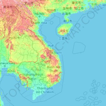
Name: Vietnam topographic map, elevation, terrain.
Location: Vietnam (7.69209 102.14386 23.39269 114.85726)
Average elevation: 173 m
Minimum elevation: -3 m
Maximum elevation: 2,808 m
Other topographic maps
Click on a map to view its topography, its elevation and its terrain.
Vienna
Vienna is located in northeastern Austria, at the easternmost extension of the Alps in the Vienna Basin. The earliest settlement, at the location of today's inner city, was south of the meandering Danube while the city now spans both sides of the river. Elevation ranges from 151 to 542 m (495 to 1,778 ft). The…
Average elevation: 231 m
Africa
Average elevation: 462 m
Glasgow
United Kingdom > Scotland > Glasgow City
Glasgow itself was reputed to have been founded by the Christian missionary Saint Mungo in the 6th century. He established a church on the Molendinar Burn, where the present Glasgow Cathedral stands, and in the following years Glasgow became a religious centre. Glasgow grew over the following centuries as part…
Average elevation: 128 m
Mamelodi
South Africa > Gauteng > City of Tshwane Metropolitan Municipality
Average elevation: 1,319 m
Kumbakonam
India > Tamil Nadu > Kumbakonam
Kumbakonam is located at 10°58′N 79°25′E / 10.97°N 79.42°E / 10.97; 79.42. It is situated 273 km (170 mi) south of Chennai, 96 km (60 mi) east of Tiruchirappalli, about 40 km (25 mi) north-east of Thanjavur., and about 35 km (22 mi) south-west of Mayiladuthurai. It lies in the region called…
Average elevation: 27 m
Thuvakudi
India > Tamil Nadu > Thiruverumbur
Thuvakudi is located at 10°45′23″N 78°48′04″E / 10.756389°N 78.801111°E / 10.756389; 78.801111. The average elevation is 88 metres (289 ft). The topology of Thuvakudi is almost flat with a few isolated hillocks rising above the surface. The city spread over an area of 14.371 square…
Average elevation: 78 m
K2
Pakistan > Gilgit-Baltistan > Shigar District
Also occasionally known as Mount Godwin-Austen, other nicknames for K2 are The King of Mountains and The Mountaineers' Mountain, as well as The Mountain of Mountains after prominent Italian climber Reinhold Messner titled his book about K2 the same. Although the summit of Everest is at a higher altitude, K2 is…
Average elevation: 7,474 m
Halifax
United Kingdom > England > Calderdale
Topographically, Halifax is located in the south-eastern foothills of the moorland region called the South Pennines. Halifax is situated about 4 miles (6 km) from the M62 motorway, close to Bradford and Huddersfield. The A641 road links the town with Brighouse, Bradford and Huddersfield. The Hebble Brook joins…
Average elevation: 196 m
Le Crêt
Switzerland > Vaud > District de la Riviera-Pays-d’Enhaut > Rougemont
Average elevation: 1,229 m
Windsor Castle
United Kingdom > England > Royal Borough of Windsor and Maidenhead > Windsor > Clewer Village
Average elevation: 23 m
Asia
Average elevation: 563 m
Nakonde
This is approximately 350 kilometres (217 mi), by road, north of Mpika, the largest city in the province. The geographical coordinates of the town are: 09°19'38.0"S, 32°45'30.0"E (Latitude:-9.327222; Longitude:32.758333). The average elevation of Nakonde is about 1,306 metres (4,285 ft), above sea level.…
Average elevation: 1,613 m
Seto Inland Sea
Average elevation: 5 m
Mount Everest
Nepal > Koshi Province > Solukhumbu
Mount Everest, known officially and locally as Sagarmatha in Nepal or Qomolangma in Tibet, is Earth's highest mountain above sea level, located in the Mahalangur Himal sub-range of the Himalayas. The China–Nepal border runs across its summit point. Its elevation (snow height) of 8,848.86 m (29,031 ft 8+1⁄2…
Average elevation: 7,847 m
Harrogate
United Kingdom > England > North Yorkshire
Harrogate is situated on the edge of the Yorkshire Dales, with the Vale of York to the east and the upland Yorkshire Dales to the west and north-west. It has a dry and mild climate, typical of places in the rain shadow of the Pennines. It is on the A59 from Skipton to York. At an altitude of between 100 and…
Average elevation: 106 m
Randburg
South Africa > Gauteng > City of Johannesburg Metropolitan Municipality
Average elevation: 1,567 m
Medina
Saudi Arabia > Medina Province
Medina is located in the Hejaz region which is a 200 km (120 mi) wide strip between the Nafud desert and the Red Sea. Located approximately 720 km (450 mi) northwest of Riyadh which is at the center of the Saudi desert, the city is 250 km (160 mi) away from the west coast of Saudi Arabia and at an elevation of…
Average elevation: 692 m
Dullstroom
South Africa > Mpumalanga > Nkangala > Emakhazeni Local Municipality
Due to its high elevation (Dullstroom being the highest town in South Africa itself), Dullstroom has a subtropical highland climate (Köppen: Cwb). From October to April, the town sees a significant amount of rainfall (higher than nearby Johannesburg to the west), in contrast with winter, where precipitation…
Average elevation: 2,009 m
Klerksdorp
South Africa > North West > Dr Kenneth Kaunda District Municipality
Average elevation: 1,346 m
San Luis Potosí City
San Luis Potosí, commonly referred to as San Luis, or by its initials SLP (Otomi: Nmiñ'u), is the capital and the most populous city of the Mexican state of San Luis Potosí. It is the municipal seat of the surrounding municipality of San Luis Potosí. The city lies at an elevation of 1,864 metres (6,115…
Average elevation: 2,004 m
Meteora
Greece > Thessaly and Central Greece > Trikala Regional Unit > Kastraki
The Monastery of Rousanou is believed to have been constructed, like many of the other monasteries, in the 14th century. The cathedral is believed to have been built in the 16th century and later decorated in 1540. The name Rousanou is believed to come from the first group of monks who settled on the rock from…
Average elevation: 429 m