
Jamestown topographic map
Interactive map
Click on the map to display elevation.
About this map
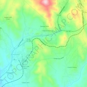
Name: Jamestown topographic map, elevation, terrain.
Average elevation: 506 m
Minimum elevation: 403 m
Maximum elevation: 735 m
Other topographic maps
Click on a map to view its topography, its elevation and its terrain.
Kentfield
United States > California > Marin County > Kentfield
Kentfield (formerly Ross Landing, Tamalpais, and Kent) is a census-designated place (CDP) in Marin County, California, United States, just north of San Francisco. Kentfield is located 2 miles (3 km) southwest of downtown San Rafael, at an elevation of 115 feet (35 m). The population was 6,808 at the 2020…
Average elevation: 151 m
Los Angeles
United States > California > Los Angeles County
Los Angeles is characterized by a diverse and dynamic topography. The city is predominantly situated in a basin bordered by mountain ranges, including the Santa Monica Mountains to the north and the San Gabriel Mountains to the east, with elevations reaching up to about 10,000 feet (3,048 meters) in certain…
Average elevation: 241 m