
Make a donation
Côte d'Ivoire topographic map
Click on the map to display elevation.
Make a donation
About this map
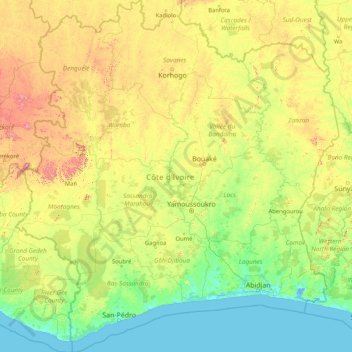
Name: Côte d'Ivoire topographic map, elevation, terrain.
Location: Côte d'Ivoire (4.16212 -8.60147 10.74020 -2.49294)
Average elevation: 244 m
Minimum elevation: -2 m
Maximum elevation: 1,644 m
Make a donation
Other topographic maps
Click on a map to view its topography, its elevation and its terrain.
Vienna
Vienna is located in northeastern Austria, at the easternmost extension of the Alps in the Vienna Basin. The earliest settlement, at the location of today's inner city, was south of the meandering Danube while the city now spans both sides of the river. Elevation ranges from 151 to 542 m (495 to 1,778 ft). The…
Average elevation: 231 m
Make a donation
Philippine Sea
Average elevation: 0 m
Make a donation
Make a donation
Make a donation
Chinsali
The geographical coordinates of Chinsali Town are 10°33'08.0"S, 32°04'09.0"E (Latitude:-10.552222; Longitude:32.069167). The town is nestled at an average elevation of 1,383 metres (4,537 ft) above mean sea level.
Average elevation: 1,294 m
Make a donation
Kotli
India > Himachal Pradesh > Kotli
Kotli Tungal (Kotli) is a small town in Himachal Pradesh, in northern India located along national highway 70 (updated 003) which connects Jalandhar (in Punjab) to Mandi. It is 22 km (14 mi) from the town of Mandi, Kotli is a Sub Division and Tehsil (Sub District) of Mandi District. Kotli and the surrounding…
Average elevation: 1,194 m
Make a donation
Make a donation
Culiacán
Culiacán is located in the central region of the State of Sinaloa, forming part of the Northwest of Mexico. The coordinates that correspond to it are 24 ° 48'15 "N (latitude) by 107 ° 25'52" W (West), with an altitude of 54 meters above sea level.
Average elevation: 85 m
Make a donation
Make a donation
Naqamte
Nekemte, also spelled as Neqemte (Oromo: Naqamtee, Amharic: ነቀምት), is a market city and separate woreda in western Ethiopia. Located in the East Welega Zone of the Oromia Region, Nekemte has a latitude and longitude of 9°5′N 36°33′E / 9.083°N 36.550°E / 9.083; 36.550 and an elevation of 2,088 meters.
Average elevation: 1,909 m
Make a donation
Make a donation
Ida
The summit is windswept and bare with a relatively low tree line due to exposure, but the slopes of this mountain, at the edge of mild Mediterranean and colder central Anatolian climate zones, hold a wealth of endemic flora, marooned here after the Ice Age. The climate at lower altitudes has become…
Average elevation: 1,457 m
Make a donation
Make a donation
Make a donation
Puebla City
Mexico > Puebla > Municipio de Puebla
The Sierra del Tentzon and higher elevations of Malinche volcano still conserve the Trans-Mexican Volcanic Belt pine-oak forests ecoregion – with forests of pine, holm oak and other tree species. In the pine forests, Montezuma Pine (Pinus montezumae) is generally predominant, with Hartweg's Pine (Pinus…
Average elevation: 2,233 m
Gudelji
Bosnia and Herzegovina > Federation of Bosnia and Herzegovina > Jazvine
Average elevation: 472 m
Make a donation
Abuja
Nigeria > Federal Capital Territory > Municipal Area Council
The elevation is 360 metres (1,180 ft).
Average elevation: 508 m
Lima
The suburban district of Cieneguilla, the district of Pachacámac and the district of Chosica provide important tourist attractions among locals. Due to its elevation (over 500 masl), the sun shines in Chosica during the winter, being very visited by the residents of Lima to escape the urban fog.
Average elevation: 236 m
Make a donation
Make a donation
Vértes
The area of the Vértes occupies 314 km2 (121 sq mi). It is about 30 km long and 10–15 km wide. The average altitude is above sea level is 350 meters; its highest points are 487 m (Nagy-Csákány), 480 m (Körtvélyes) and 479 m (Csóka-hegy). Geologically the Vértes constitute a fairly uniform structure.…
Average elevation: 245 m
Make a donation
Lost Peak
Canada > British Columbia > Squamish-Lillooet Regional District > Area B (Cayoosh/Pavilion)
Average elevation: 2,176 m
Make a donation
Make a donation
Lippisbacher Hof
Germany > Baden-Württemberg > Landkreis Lörrach > Obereggenen
Average elevation: 645 m
Black Dome Mountain
Canada > British Columbia > Thompson-Nicola Regional District > Area E (Bonaparte Plateau)
Average elevation: 1,931 m
Shirakawa
Shirakawa is a mountain village located in far northern Gifu Prefecture, bordering Ishikawa Prefecture and Toyama Prefecture on the Ryōhaku Mountains. Mount Hakusan is the highest elevation at 2,172 metres (7,126 ft). The village's area is 95.7% mountainous forests, and its steep places are characteristic. In…
Average elevation: 667 m
Make a donation
Solwezi
Zambia > North-Western Province
Solwezi is located on the Chingola–Solwezi–Mwinilunga Road (T5 Road of Zambia), approximately 177 kilometres (110 mi) north-west of Chingola and approximately 275 kilometres (171 mi) south-east of Mwinilunga, in the extreme northwest of the country. The geographical coordinates of the city…
Average elevation: 1,352 m
Make a donation
Make a donation
Dordrecht
South Africa > Eastern Cape > Chris Hani District Municipality > Emalahleni Local Municipality
Average elevation: 1,678 m
Prenj
Bosnia and Herzegovina > Federation of Bosnia and Herzegovina > Town of Stolac
Average elevation: 169 m
Make a donation
Make a donation