
湘潭市 topographic map
Interactive map
Click on the map to display elevation.
About this map
Name: 湘潭市 topographic map, elevation, terrain.
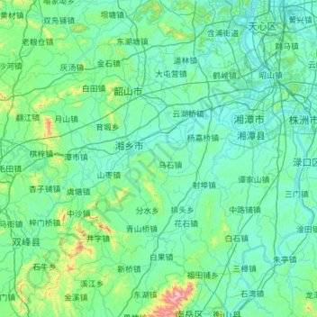
Location: 湘潭市, 湖南省, 中国 (27.34181 111.99513 28.07724 113.08556)
Average elevation: 121 m
Minimum elevation: 21 m
Maximum elevation: 1,234 m
湘潭市地处湖南中部偏东,周边与地级市长沙、株洲、衡阳与娄底相邻。全境总面积5006平方公里,东西横宽108公里,南北纵长81公里。总的地貌轮廓是北、西、南地势高,中部、东部地势低平。湘江在市区呈C形穿境而过,形成42公里的回弯,并接纳流经湘潭县的涓水,流经湘乡市、湘潭县的涟水。全市属湘中丘陵盆地。近80%的面积在海拔150米以下,最高802米,市区最高299.1米,最低29.9米。地貌类型多样,在全部土地中,山地占12.12%;丘陵占19.25%;岗地占32.05%;平原占28.05%;水面占8.53%。
Other topographic maps
Click on a map to view its topography, its elevation and its terrain.