Geolocate

千家峒瑶族乡 topographic map

Interactive map

Click on the map to display elevation.

About this map

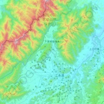
Name: 千家峒瑶族乡 topographic map, elevation, terrain.

Location: 千家峒瑶族乡, 江永县, 永州市, 湖南省, 中国 (25.19845 111.09642 25.47882 111.36661)

Average elevation: 543 m

Minimum elevation: 190 m

Maximum elevation: 1,890 m

Other topographic maps

Click on a map to view its topography, its elevation and its terrain.

工业园社区村

中国 > 湖南省 > 江永县 > 潇浦镇

Average elevation: 292 m

古调村

中国 > 湖南省 > 江永县 > 源口瑶族乡

Average elevation: 300 m

上甘棠村

中国 > 湖南省 > 江永县 > 夏层铺镇

Average elevation: 285 m

回龙圩管理区

中国 > 湖南省 > 江永县 > 回龙圩镇

Average elevation: 380 m

兴隆村

中国 > 湖南省 > 江永县 > 回龙圩镇

Average elevation: 391 m

玉井

中国 > 湖南省 > 江永县 > 千家峒瑶族乡

Average elevation: 266 m

花果山

中国 > 湖南省 > 江永县 > 上江圩镇

Average elevation: 298 m

江永县

中国 > 湖南省 > 江永县 > 潇浦镇

北部为都庞岭,最高海拔1951米(杉木顶)。

Average elevation: 470 m