
中卫市 topographic map
Interactive map
Click on the map to display elevation.
About this map
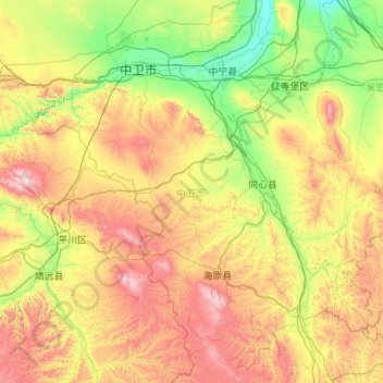
Name: 中卫市 topographic map, elevation, terrain.
Location: 中卫市, 宁夏回族自治区, 755000, 中国 (36.12125 104.28420 37.74907 106.46619)
Average elevation: 1,670 m
Minimum elevation: 1,152 m
Maximum elevation: 2,985 m
Other topographic maps
Click on a map to view its topography, its elevation and its terrain.