
玉林市 topographic map
Interactive map
Click on the map to display elevation.
About this map
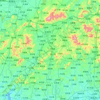
Name: 玉林市 topographic map, elevation, terrain.
Location: 玉林市, 广西壮族自治区, 543000, 中国 (21.63026 109.53980 23.13106 110.89477)
Average elevation: 152 m
Minimum elevation: 0 m
Maximum elevation: 1,216 m
Other topographic maps
Click on a map to view its topography, its elevation and its terrain.
岑王老山国家级自然保护区
岑王老山国家级自然保护区, 浪平镇, 田林县, 百色市, 广西壮族自治区, 中国
Average elevation: 1,236 m