
South Sumatra topographic map
Interactive map
Click on the map to display elevation.
About this map
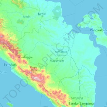
Name: South Sumatra topographic map, elevation, terrain.
Location: South Sumatra, Sumatra, Indonesia (-4.92416 102.05323 -1.51384 106.60263)
Average elevation: 123 m
Minimum elevation: -3 m
Maximum elevation: 2,774 m
On the east coast the land consists of swamps and brackets which are affected by tides. Its vegetation is in the form of palmate plants and mangrove. A little more western is a vast lowland. Far to the west near the border of Bengkulu and Jambi lies the Bukit Barisan mountains, which divides South Sumatra and is a mountainous area with an altitude of 900 to 1,200 metres (3,000 to 3,900 ft) above sea level. Barisan Hill consists of the summit of Mount Seminung (1,964 metres or 6,444 feet asl), Mount Dempo (3,159 metres or 10,364 feet asl), Mount Patah (1,107 metres or 3,632 feet asl), and Mount Bungkuk (2,125 metres or 6,972 feet asl). To the west of Bukit Barisan is a slope. In the Bukit Barisan valley there are areas of rubber, oil palm, and agriculture plantations, especially coffee, tea and vegetables. Mount Dempo is the highest point in the province.
Other topographic maps
Click on a map to view its topography, its elevation and its terrain.
West Nusa Tenggara
West Nusa Tenggara, Lesser Sunda Islands, Indonesia
Average elevation: 45 m
Calaca
Indonesia > North Sulawesi > Manado
Calaca, Manado, North Sulawesi, Sulawesi, 95122, Indonesia
Average elevation: 11 m
East Nusa Tenggara
East Nusa Tenggara, Lesser Sunda Islands, Indonesia
Average elevation: 31 m
Special Capital Region of Jakarta
Special Capital Region of Jakarta, Java, Indonesia
Average elevation: 5 m
Kelimutu
Indonesia > East Nusa Tenggara > Ende
Kelimutu, Ende, East Nusa Tenggara, 86373, Indonesia
Average elevation: 1,469 m
Makete
Indonesia > North Maluku > Halmahera Utara > Makete
Makete, Halmahera Utara, North Maluku, Indonesia
Average elevation: 32 m
Kedungjenar
Indonesia > Central Java > Kedungjenar
Kedungjenar, Blora, Central Java, Indonesia
Average elevation: 88 m
Karang
Indonesia > Central Java > Karang
Karang, Pati, Central Java, 59185, Indonesia
Average elevation: 8 m
Dauh Puri Kangin
Indonesia > Bali > Denpasar > Dauh Puri Kangin
Dauh Puri Kangin, Denpasar Barat, Denpasar, Bali, 80232, Indonesia
Average elevation: 26 m
Tanjung Raya
Indonesia > Lampung > Tanjung Raya
Tanjung Raya, Lampung, 35119, Indonesia
Average elevation: 80 m
RW 03
Indonesia > Jakarta Special Capital Region > Kelapa Gading Barat
RW 03, Kelapa Gading Barat, Kelapa Gading, North Jakarta, Jakarta Special Capital Region, 14240, Indonesia
Average elevation: 5 m
Rinjani
Indonesia > West Nusa Tenggara > Mataram
Rinjani, Mataram, Lombok Utara, West Nusa Tenggara, Indonesia
Average elevation: 3,071 m
Bangka Island
Indonesia > North Sulawesi > Bitung
Bangka Island, Bitung, North Sulawesi, Indonesia
Average elevation: 35 m
Karanganyar
Indonesia > Central Java > Semarang
Karanganyar, Tugu, Semarang, Central Java, Indonesia
Average elevation: 7 m
Gunung Bandahara
Gunung Bandahara, Putri Betung, Gayo Lues, Aceh, Indonesia
Average elevation: 2,634 m
Fuyul Sojol
Fuyul Sojol, Parigi Moutong Regency, Central Sulawesi, Indonesia
Average elevation: 2,422 m