
Thank you for supporting this site ❤️
Make a donation
Make a donation
Aceh Besar topographic map
Click on the map to display elevation.
Thank you for supporting this site ❤️
Make a donation
Make a donation
About this map
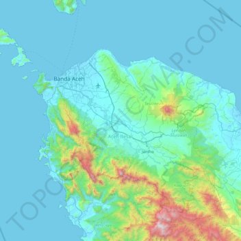
Name: Aceh Besar topographic map, elevation, terrain.
Location: Aceh Besar, Aceh, Indonesia (5.05198 95.01066 5.76461 95.84049)
Average elevation: 238 m
Minimum elevation: -3 m
Maximum elevation: 2,269 m
Thank you for supporting this site ❤️
Make a donation
Make a donation