
Gorontalo topographic map
Interactive map
Click on the map to display elevation.
About this map
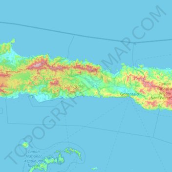
Name: Gorontalo topographic map, elevation, terrain.
Location: Gorontalo, Sulawesi, Indonesia (-0.06656 121.16123 1.36471 123.55192)
Average elevation: 90 m
Minimum elevation: -1 m
Maximum elevation: 2,119 m
Topographically, the province is relatively low (0–40o), with the elevation ranging between 0–2,400 m (7,900 ft) above sea level. Its coastline length is more than 590 km (370 mi). Counting the Exclusive Economic Zone to the north where Philippines is at the border, the total sea area of the province is more than 50,500 km2 (19,500 sq mi). There are some small islands around the north and the south of the province, 67 of which have been identified and named.
Other topographic maps
Click on a map to view its topography, its elevation and its terrain.
West Nusa Tenggara
West Nusa Tenggara, Lesser Sunda Islands, Indonesia
Average elevation: 45 m
Calaca
Indonesia > North Sulawesi > Manado
Calaca, Manado, North Sulawesi, Sulawesi, 95122, Indonesia
Average elevation: 11 m
East Nusa Tenggara
East Nusa Tenggara, Lesser Sunda Islands, Indonesia
Average elevation: 31 m
Special Capital Region of Jakarta
Special Capital Region of Jakarta, Java, Indonesia
Average elevation: 5 m
Kelimutu
Indonesia > East Nusa Tenggara > Ende
Kelimutu, Ende, East Nusa Tenggara, 86373, Indonesia
Average elevation: 1,469 m
Makete
Indonesia > North Maluku > Halmahera Utara > Makete
Makete, Halmahera Utara, North Maluku, Indonesia
Average elevation: 32 m
Kedungjenar
Indonesia > Central Java > Kedungjenar
Kedungjenar, Blora, Central Java, Indonesia
Average elevation: 88 m
Karang
Indonesia > Central Java > Karang
Karang, Pati, Central Java, 59185, Indonesia
Average elevation: 8 m
Dauh Puri Kangin
Indonesia > Bali > Denpasar > Dauh Puri Kangin
Dauh Puri Kangin, Denpasar Barat, Denpasar, Bali, 80232, Indonesia
Average elevation: 26 m
Tanjung Raya
Indonesia > Lampung > Tanjung Raya
Tanjung Raya, Lampung, 35119, Indonesia
Average elevation: 80 m
RW 03
Indonesia > Jakarta Special Capital Region > Kelapa Gading Barat
RW 03, Kelapa Gading Barat, Kelapa Gading, North Jakarta, Jakarta Special Capital Region, 14240, Indonesia
Average elevation: 5 m
Rinjani
Indonesia > West Nusa Tenggara > Mataram
Rinjani, Mataram, Lombok Utara, West Nusa Tenggara, Indonesia
Average elevation: 3,071 m
Bangka Island
Indonesia > North Sulawesi > Bitung
Bangka Island, Bitung, North Sulawesi, Indonesia
Average elevation: 35 m
Karanganyar
Indonesia > Central Java > Semarang
Karanganyar, Tugu, Semarang, Central Java, Indonesia
Average elevation: 7 m
Gunung Bandahara
Gunung Bandahara, Putri Betung, Gayo Lues, Aceh, Indonesia
Average elevation: 2,634 m
Fuyul Sojol
Fuyul Sojol, Parigi Moutong Regency, Central Sulawesi, Indonesia
Average elevation: 2,422 m