
Daviess County topographic map
Interactive map
Click on the map to display elevation.
About this map
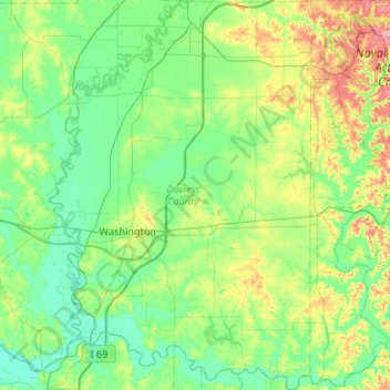
Name: Daviess County topographic map, elevation, terrain.
Location: Daviess County, Indiana, United States (38.49037 -87.27942 38.90418 -86.90423)
Average elevation: 154 m
Minimum elevation: 123 m
Maximum elevation: 251 m
The terrain of Daviess County is hilly, with its area completely devoted to agriculture or urban development. Its highest elevation (740 ft; 230 m ASL) is a rise one mile (1.6 km) NNE of Farlen. The county is drained by the White River flowing to the southwest, whose two main forks (East White and West White) come together at the county's SW corner. The county's west boundary is defined by the West White River's course and its south boundary is defined by the East White River's course; their confluence defines the county's corner point.
Other topographic maps
Click on a map to view its topography, its elevation and its terrain.
Fosters Ridge
United States > Indiana > Perry County
Fosters Ridge, Perry County, Indiana, 47515, United States
Average elevation: 196 m
Indianapolis
United States > Indiana > Indianapolis
Indianapolis, Marion County, Indiana, 46204, United States
Average elevation: 241 m
Carmel
United States > Indiana > Hamilton County
Carmel, Hamilton County, Indiana, United States
Average elevation: 253 m
West Harrison
United States > Indiana > Dearborn County
West Harrison, Harrison Township, Dearborn County, Indiana, United States
Average elevation: 177 m
Mount Etna
United States > Indiana > Huntington County
Mount Etna, Huntington County, Indiana, United States
Average elevation: 245 m
Terre Haute
United States > Indiana > Vigo County
Terre Haute, Vigo County, Indiana, United States
Average elevation: 159 m
Center Township
United States > Indiana > Lake County
Center Township, Lake County, Indiana, 46307, United States
Average elevation: 220 m
Springville
United States > Indiana > LaPorte County
Springville, LaPorte County, Indiana, United States
Average elevation: 229 m
Mount Vernon
United States > Indiana > Posey County
Mount Vernon, Posey County, Indiana, United States
Average elevation: 120 m
Halifax Park
United States > Indiana > Hamilton County > Carmel
Halifax Park, Carmel, Hamilton County, Indiana, United States
Average elevation: 274 m
Wheatfield
United States > Indiana > Jasper County
Wheatfield, Jasper County, Indiana, United States
Average elevation: 203 m
Fish Creek
United States > Indiana > LaPorte County > Fish Lake
Fish Creek, Fish Lake, LaPorte County, Indiana, United States
Average elevation: 217 m
Wanatah
United States > Indiana > LaPorte County
Wanatah, LaPorte County, Indiana, 46390, United States
Average elevation: 223 m
Elwood
United States > Indiana > Madison County
Elwood, Madison County, Indiana, 46036, United States
Average elevation: 264 m
Angola
United States > Indiana > Steuben County
Angola, Steuben County, Indiana, United States
Average elevation: 315 m
Arlington
United States > Indiana > Rush County
Arlington, Rush County, Indiana, 46104, United States
Average elevation: 280 m
Cicero
United States > Indiana > Hamilton County
Cicero, Hamilton County, Indiana, 46034, United States
Average elevation: 252 m
Vanderburgh County
Vanderburgh County, Indiana, United States
Average elevation: 127 m
Larwill
United States > Indiana > Whitley County
Larwill, Whitley County, Indiana, United States
Average elevation: 288 m
Winfield Township
United States > Indiana > Lake County
Winfield Township, Lake County, Indiana, United States
Average elevation: 220 m
Hartleyville
United States > Indiana > Lawrence County
Hartleyville, Lawrence County, Indiana, United States
Average elevation: 185 m
Muncie
United States > Indiana > Delaware County
Muncie, Delaware County, Indiana, United States
Average elevation: 291 m
Sellersburg
United States > Indiana > Clark County
Sellersburg, Clark County, Indiana, 47172, United States
Average elevation: 149 m
Union City
United States > Indiana > Randolph County
Union City, Randolph County, Indiana, United States
Average elevation: 333 m
La Paz
United States > Indiana > Marshall County
La Paz, Marshall County, Indiana, 46537, United States
Average elevation: 261 m
Selma
United States > Indiana > Delaware County
Selma, Delaware County, Indiana, United States
Average elevation: 304 m
Bright
United States > Indiana > Dearborn County
Bright, Miller Township, Dearborn County, Indiana, United States
Average elevation: 222 m
Beamer
United States > Indiana > Owen County
Beamer, Owen County, Indiana, United States
Average elevation: 206 m
Bristow
United States > Indiana > Perry County
Bristow, Perry County, Indiana, United States
Average elevation: 157 m
Upland
United States > Indiana > Grant County
Upland, Grant County, Indiana, United States
Average elevation: 278 m
Lawrence County
Lawrence County, Indiana, United States
Average elevation: 203 m
Evansville
United States > Indiana > Vanderburgh County
Evansville, Vanderburgh County, Indiana, United States
Average elevation: 122 m
Ohio County
Ohio County, Indiana, 47040, United States
Average elevation: 223 m
Parkers Settlement
United States > Indiana > Posey County
Parkers Settlement, Posey County, Indiana, United States
Average elevation: 141 m
Lake James
United States > Indiana > Steuben County
Lake James, Steuben County, Indiana, 46703, United States
Average elevation: 303 m
Vincennes
United States > Indiana > Knox County
Vincennes, Knox County, Indiana, 47591, United States
Average elevation: 134 m
Saint Joseph County
Saint Joseph County, Indiana, United States
Average elevation: 239 m
West Lafayette
United States > Indiana > Tippecanoe County
West Lafayette, Tippecanoe County, Indiana, United States
Average elevation: 192 m
Twin Lakes
United States > Indiana > LaGrange County
Twin Lakes, LaGrange County, Indiana, United States
Average elevation: 262 m
Bartholomew County
Bartholomew County, Indiana, United States
Average elevation: 209 m
Henryville
United States > Indiana > Clark County
Henryville, Clark County, Indiana, 47126, United States
Average elevation: 166 m