
Porter topographic map
Interactive map
Click on the map to display elevation.
About this map
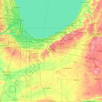
Name: Porter topographic map, elevation, terrain.
Location: Porter, Indiana, 46385, United States (40.74570 -87.77250 42.14570 -86.37250)
Average elevation: 207 m
Minimum elevation: 171 m
Maximum elevation: 286 m
Other topographic maps
Click on a map to view its topography, its elevation and its terrain.
Fosters Ridge
United States > Indiana > Perry County
Fosters Ridge, Perry County, Indiana, 47515, United States
Average elevation: 196 m
Indianapolis
United States > Indiana > Indianapolis
Indianapolis, Marion County, Indiana, 46204, United States
Average elevation: 241 m
Carmel
United States > Indiana > Hamilton County
Carmel, Hamilton County, Indiana, United States
Average elevation: 253 m
West Harrison
United States > Indiana > Dearborn County
West Harrison, Harrison Township, Dearborn County, Indiana, United States
Average elevation: 177 m
Mount Etna
United States > Indiana > Huntington County
Mount Etna, Huntington County, Indiana, United States
Average elevation: 245 m
Terre Haute
United States > Indiana > Vigo County
Terre Haute, Vigo County, Indiana, United States
Average elevation: 159 m
Center Township
United States > Indiana > Lake County
Center Township, Lake County, Indiana, 46307, United States
Average elevation: 220 m
Springville
United States > Indiana > LaPorte County
Springville, LaPorte County, Indiana, United States
Average elevation: 229 m
Mount Vernon
United States > Indiana > Posey County
Mount Vernon, Posey County, Indiana, United States
Average elevation: 120 m
Halifax Park
United States > Indiana > Hamilton County > Carmel
Halifax Park, Carmel, Hamilton County, Indiana, United States
Average elevation: 274 m
Wheatfield
United States > Indiana > Jasper County
Wheatfield, Jasper County, Indiana, United States
Average elevation: 203 m
Fish Creek
United States > Indiana > LaPorte County > Fish Lake
Fish Creek, Fish Lake, LaPorte County, Indiana, United States
Average elevation: 217 m
Wanatah
United States > Indiana > LaPorte County
Wanatah, LaPorte County, Indiana, 46390, United States
Average elevation: 223 m
Elwood
United States > Indiana > Madison County
Elwood, Madison County, Indiana, 46036, United States
Average elevation: 264 m
Angola
United States > Indiana > Steuben County
Angola, Steuben County, Indiana, United States
Average elevation: 315 m
Arlington
United States > Indiana > Rush County
Arlington, Rush County, Indiana, 46104, United States
Average elevation: 280 m
Cicero
United States > Indiana > Hamilton County
Cicero, Hamilton County, Indiana, 46034, United States
Average elevation: 252 m
Vanderburgh County
Vanderburgh County, Indiana, United States
Average elevation: 127 m
Larwill
United States > Indiana > Whitley County
Larwill, Whitley County, Indiana, United States
Average elevation: 288 m
Winfield Township
United States > Indiana > Lake County
Winfield Township, Lake County, Indiana, United States
Average elevation: 220 m
Hartleyville
United States > Indiana > Lawrence County
Hartleyville, Lawrence County, Indiana, United States
Average elevation: 185 m
Muncie
United States > Indiana > Delaware County
Muncie, Delaware County, Indiana, United States
Average elevation: 291 m
Sellersburg
United States > Indiana > Clark County
Sellersburg, Clark County, Indiana, 47172, United States
Average elevation: 149 m
Union City
United States > Indiana > Randolph County
Union City, Randolph County, Indiana, United States
Average elevation: 333 m
La Paz
United States > Indiana > Marshall County
La Paz, Marshall County, Indiana, 46537, United States
Average elevation: 261 m
Selma
United States > Indiana > Delaware County
Selma, Delaware County, Indiana, United States
Average elevation: 304 m
Bright
United States > Indiana > Dearborn County
Bright, Miller Township, Dearborn County, Indiana, United States
Average elevation: 222 m
Beamer
United States > Indiana > Owen County
Beamer, Owen County, Indiana, United States
Average elevation: 206 m
Bristow
United States > Indiana > Perry County
Bristow, Perry County, Indiana, United States
Average elevation: 157 m
Upland
United States > Indiana > Grant County
Upland, Grant County, Indiana, United States
Average elevation: 278 m
Lawrence County
Lawrence County, Indiana, United States
Average elevation: 203 m
Evansville
United States > Indiana > Vanderburgh County
Evansville, Vanderburgh County, Indiana, United States
Average elevation: 122 m
Ohio County
Ohio County, Indiana, 47040, United States
Average elevation: 223 m
Parkers Settlement
United States > Indiana > Posey County
Parkers Settlement, Posey County, Indiana, United States
Average elevation: 141 m
Lake James
United States > Indiana > Steuben County
Lake James, Steuben County, Indiana, 46703, United States
Average elevation: 303 m
Vincennes
United States > Indiana > Knox County
Vincennes, Knox County, Indiana, 47591, United States
Average elevation: 134 m
Saint Joseph County
Saint Joseph County, Indiana, United States
Average elevation: 239 m
West Lafayette
United States > Indiana > Tippecanoe County
West Lafayette, Tippecanoe County, Indiana, United States
Average elevation: 192 m
Twin Lakes
United States > Indiana > LaGrange County
Twin Lakes, LaGrange County, Indiana, United States
Average elevation: 262 m
Bartholomew County
Bartholomew County, Indiana, United States
Average elevation: 209 m
Henryville
United States > Indiana > Clark County
Henryville, Clark County, Indiana, 47126, United States
Average elevation: 166 m