
宍道湖 topographic map
Interactive map
Click on the map to display elevation.
About this map
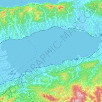
Name: 宍道湖 topographic map, elevation, terrain.
Location: 宍道湖, 松江市, 島根県, 日本 (35.40672 132.86466 35.48057 133.05391)
Average elevation: 67 m
Minimum elevation: -4 m
Maximum elevation: 468 m
宍道湖や中海の地形は時代と共に変化し、縄文時代早期には海進期にあたる。同時期に宍道湖は大社湾と接続し古宍道湾となり、中海は美保湾と接続して古中海湾となり、沿岸には谷部が形成された。後に古宍道湾は砂州の発達や河川の沖積により閉塞し、古中海湾も同様の作用で閉塞し、現在の地形が形成された。
Other topographic maps
Click on a map to view its topography, its elevation and its terrain.