
宜宾市 topographic map
Interactive map
Click on the map to display elevation.
About this map
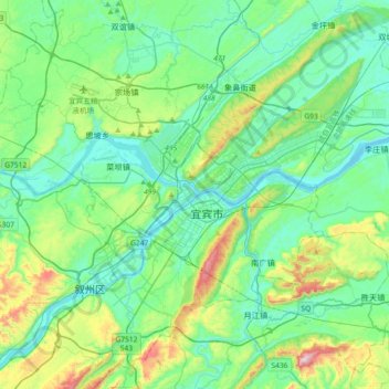
Name: 宜宾市 topographic map, elevation, terrain.
Location: 宜宾市, 南城街道, 翠屏区, 宜宾市, 四川省, 中国 (28.61019 104.46896 28.93019 104.78896)
Average elevation: 386 m
Minimum elevation: 248 m
Maximum elevation: 876 m
宜宾在东经103°36'-105°20' 、北纬27°50'-29°16'之间,东西最大横距153.2公里,南北最大纵距150.4公里。地貌大致分为东北和西南两大部分,东部是海拔500米以下的丘陵区,地面起伏不大;西南部是海拔500-2000米的中低山地,最高点为老君山(2,008米)。
Other topographic maps
Click on a map to view its topography, its elevation and its terrain.