
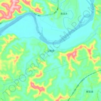
江陵镇 topographic map
Interactive map
Click on the map to display elevation.
江陵镇 topographic map, elevation, terrain
About this map
Name: 江陵镇 topographic map, elevation, terrain.
Location: 江陵镇, 高坪区, 南充市, 四川省, 中国 (30.89933 106.19992 30.97933 106.27992)
Average elevation: 320 m
Minimum elevation: 267 m
Maximum elevation: 479 m
Other topographic maps
Click on a map to view its topography, its elevation and its terrain.
成都市
成都市区海拔500余米。成都境内的地形较为复杂,东部为龙泉山脉和盆中丘陵,龙泉山脉海拔600至1000米,植被破坏较为严重,该山脉为成都平原和盆中丘陵的分界线,龙泉山脉以东,浅丘连绵起伏。中部为成都平原,介于龙泉山脉与邛崃山脉之间,海拔450至720米,是由岷江、沱江及其支流冲积而成的冲积扇平原。成都平原得益于都江堰水利工程,河网密布,同时由于土地肥沃,是中国最重要的粮食产区之一。西部为邛崃山脉,是横断山脉最东缘的山系,以东北-西南走向穿过彭州、都江堰市、大邑县、崇州市和邛崃市,许多山峰海拔在4000米以上。该地区海拔落差巨大,地貌丰富,拥有丰富绮丽的自然景观。平原面积占40.1%,丘陵面积占27.6%,山区面积3…
Average elevation: 913 m
都江堰市
都江堰市地处成都平原的西北边缘,西北为山地,东南距成都市48公里。介于东经103°25'42"~103°47',北纬30°44'54"~31°22'9"之间。东西宽54公里,南北长68公里,都江堰市总面积1,208平方千米。地跨川西龙门山地带和成都平原岷江冲积扇扇顶部位。市境内地势西北高,东南低,全市山地丘陵面积占65.79%,平坝面积占34.21%。地势从高山、中山到低山再到平原逐级降低,海拔592~4,582米,相对高差3,900米。都江堰市在地质构造体系上,属华夏构造体系,跨成都平原和龙门山地区两个不同自然地理区,地貌单元属岷江冲积扇一级阶地。地势西北高,东南低,高山、中山、低山、丘陵和平原呈阶梯分布,山地、…
Average elevation: 1,517 m
攀枝花市
攀枝花市位于四川省西南部,介于北纬26°05′~27°21′,东经102°15′~108°08′之间,面积7440.398平方千米。其西跨横断山脉,东临大凉山山脉,北接大雪山,南抵百草岭。地势西北高,东南低。攀枝花市东部为小相岭-螺髻山-鲁南山系,中部为牦牛山-龙肘山系,西部为锦屏山-柏林山系,山脉走向近于南北。境内最高点为西北部盐边县境内的百灵山穿洞子,海拔4195.5米;最低点是东南部仁和区平地镇的师庄,海拔937米。城市区海拔在1000~1200米之间,主要农业区海拔在1000~1800米之间。金沙江、雅砻江、安宁河、大河、三源河及其支流深嵌在山地之间,形成雄伟的川西南峡谷区。攀枝花市地貌类型复杂多样,可分为…
Average elevation: 1,994 m
峨眉山
峨眉山,亦作峨嵋山,位于中华人民共和国四川省峨眉山市境内,景区面积154平方公里,最高峰万佛顶海拔3099米,佛教圣地华藏寺所在地金顶(3077米)成为了峨眉山旅游的最高点。地势陡峭,风景秀丽,有“峨眉天下秀”之美誉。气候多样化,植被丰富,共有3000多种植物,其中包括世界上稀有的树种。山路沿途有较多猴群,常结队向游人讨食,成为峨眉一大特色。它是中国四大佛教名山之一,有寺庙约26座,重要的有八大寺庙,佛事频繁。据传为佛教中普贤菩萨的道场。1996年12月6日,峨眉山—乐山大佛作为一项文化与自然双重遗产被联合国教科文组织列入世界遗产名录。
Average elevation: 2,600 m
九寨沟风景名胜区
九寨沟处在青藏高原东南的尕尔纳山峰北麓,主要由岷山山脉中呈“丫”字形分布的日则沟、则查洼沟、树正沟三条沟谷所构成,海拔在2000米至3106米之间,属世界高寒喀斯特地貌。总面积约620km²,约有52%的面积被原始森林所覆盖,期间夹生箭竹和各种奇花异草,也有诸多野生动物栖息于此,如大熊猫、金丝猴、白唇鹿等。在冬季,九寨溝所有海子均會結冰,唯獨五花海因為湖底的泉眼影響,令湖水在冬天仍能保持在攝氏6度。 九寨沟是白水沟上游白河的支沟,以有九个藏族村寨而得名。沟内可分四大景区:树正景区、日则景区、长海景区、宝镜崖景,以翠海、叠瀑、彩林、雪山、藏情“五绝”驰名中外,被誉为“梦仙境”和“童话世界”。
Average elevation: 3,424 m