
Arusha topographic map
Interactive map
Click on the map to display elevation.
About this map
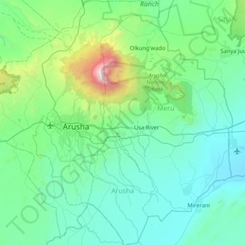
Name: Arusha topographic map, elevation, terrain.
Location: Arusha, Northern Zone, Tanzanie (-3.65555 36.46981 -3.06639 36.88906)
Average elevation: 1,349 m
Minimum elevation: 869 m
Maximum elevation: 4,506 m
Other topographic maps
Click on a map to view its topography, its elevation and its terrain.
Mount Meru
Mount Meru, Arumeru, Arusha, Northern Zone, Tanzanie
Average elevation: 3,884 m
Lac Magadi
Lac Magadi, Seneto Descent Road, Kimba, Ngorongoro, Arusha, Northern Zone, Tanzanie
Average elevation: 1,733 m
Ndutu Ranger Post
Ndutu Ranger Post, Ngorongoro, Arusha, Northern Zone, Tanzanie
Average elevation: 1,616 m
Mt Kitumbeine
Mt Kitumbeine, Monduli, Arusha, Northern Zone, Tanzanie
Average elevation: 2,694 m