
中山市 topographic map
Interactive map
Click on the map to display elevation.
About this map
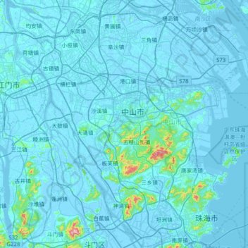
Name: 中山市 topographic map, elevation, terrain.
Location: 中山市, 广东省, 中国 (22.20574 113.15153 22.77612 113.74938)
Average elevation: 17 m
Minimum elevation: -8 m
Maximum elevation: 550 m
中山市现在的地貌主要由山地、丘陵、台地、冲积平原和海滩等组成。南部为低山丘陵区,以五桂山、竹嵩岭为主,五桂山的主峰海拔531米,是全市的最高峰。北部为平原河网区,地势顺着西江的流向自西北向东南倾斜。河流面积占了中山市全境的8%,包括有石岐河(岐江河),以及西江的几大出海口——西海水道、磨刀门水道、洪奇沥水道、横门水道、小榄水道、鸡鸦水道等。另外中山东部的珠江口上还有横门、大茅等岛屿,海岸线长26公里,浅海滩涂面积约3.19平方公里。
Other topographic maps
Click on a map to view its topography, its elevation and its terrain.