
澳門 topographic map
Interactive map
Click on the map to display elevation.
About this map
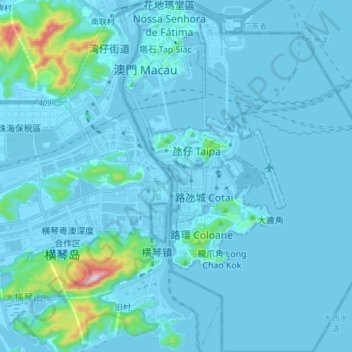
Name: 澳門 topographic map, elevation, terrain.
Location: 澳門, 中国 (22.07667 113.52817 22.21704 113.63014)
Average elevation: 27 m
Minimum elevation: -9 m
Maximum elevation: 442 m
古澳門地形基本上是丘陵地形,花崗岩地的質丘陵、台地廣佈,構成澳門地形主體。澳門的天然的平地很少,主要有半島中部、路環東南部及西南部的海積層;氹仔大小潭山之間連島沙洲;以及古時澳門島與大陸相連造成半島的蓮花莖。始於1863年的填海工程,則是主要為澳門提供平地地段的來源。填海工程使現今澳門的輪廓與數百年前大為改變,亦使海岸線趨於平直工整。
Other topographic maps
Click on a map to view its topography, its elevation and its terrain.