
Jiangsu topographic map
Interactive map
Click on the map to display elevation.
Jiangsu
Jiangsu is flat, with plains covering 68 percent of its total area (water covers another 18 percent). Most of the province stands not more than 50 meters (160 ft) above sea level. Jiangsu also has a well-developed irrigation system, which earned it (especially the southern half) the moniker of traditional Chinese: 水鄕; simplified Chinese: 水乡 (shuǐxiāng "land of water"). The southern city of Suzhou has so many canals that it has been dubbed "Venice of the East" or the "Venice of the Orient." The Grand Canal of China cuts through Jiangsu from north to south, crossing all the east–west river systems. Jiangsu also borders the Yellow Sea. The Yangtze River, the longest river of China, cuts through the province in the south and reaches the East China Sea, which divides the region into two parts: more urban, prosperous south and more poorer, rural north, and these two parts has a tense division. Mount Huaguo, near the city of Lianyungang, is the highest point in Jiangsu, at an altitude of 625 meters (2,051 ft) above sea level. Large lakes in Jiangsu include Lake Tai (the largest), Lake Hongze, Lake Gaoyou, Lake Luoma, and Lake Yangcheng.
About this map
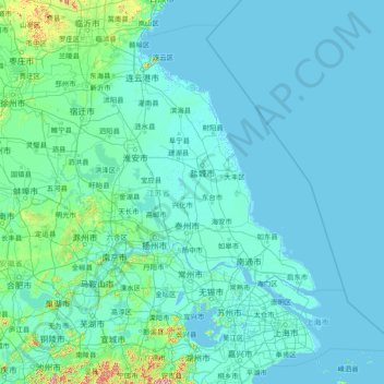
Name: Jiangsu topographic map, elevation, terrain.
Location: Jiangsu, China (30.76033 116.35520 35.16667 122.38666)
Average elevation: 24 m
Minimum elevation: -3 m
Maximum elevation: 1,144 m
Other topographic maps
Click on a map to view its topography, its elevation and its terrain.
Chongqing
The central urban area of Chongqing, or Chongqing proper, is a city of unique features. Built on mountains and partially surrounded by the Yangtze and Jialing rivers, it is known as a "mountain city" and a "city on rivers". The night scene of the city is very illuminated, with millions of lights and their…
Average elevation: 318 m
Beijing
Beijing is situated at the northern tip of the roughly triangular North China Plain, which opens to the south and east of the city. Mountains to the north, northwest and west shield the city and northern China's agricultural heartland from the encroaching desert steppes. The northwestern part of the…
Average elevation: 47 m
Mount Everest
China > Tibet > Qutang > Khumjung
Mount Everest (Chinese: 珠穆朗玛 Zhūmùlǎngmǎ; Nepali: सगरमाथा Sagarmāthā; Tibetan: Chomolungma ཇོ་མོ་གླང་མ) is Earth's highest mountain above sea level, located in the Mahalangur Himal sub-range of the Himalayas. The China–Nepal border runs across its summit…
Average elevation: 7,839 m
Nanjing
There are mainly two types of soil in Nanjing: zonal soil and cultivated soil. The zonal soil is yellow-brown soil in the northern and central areas of Nanjing, and red soil in the southern part of the border with Anhui. The cultivated soil formed by man-made farming is mainly paddy soil, and there are some…
Average elevation: 25 m
Huangshan
China > Anhui > Huangshan District
The vegetation of the area varies with elevation. Mesic forests cover the landscape below 1,100 meters. Deciduous forest stretches from 1,100 meters up to the tree line at 1,800 meters. Above that point, the vegetation consists of alpine grasslands. The area has diverse flora, where one-third of China's…
Average elevation: 754 m