
Thank you for supporting this site ❤️
Make a donation
Make a donation
Mount Everest topographic map
Click on the map to display elevation.
Thank you for supporting this site ❤️
Make a donation
Make a donation
Mount Everest
Mount Everest (Chinese: 珠穆朗玛 Zhūmùlǎngmǎ; Nepali: सगरमाथा Sagarmāthā; Tibetan: Chomolungma ཇོ་མོ་གླང་མ) is Earth's highest mountain above sea level, located in the Mahalangur Himal sub-range of the Himalayas. The China–Nepal border runs across its summit point. Its elevation (snow height) of 8,848.86 m (29,031.7 ft) was most recently established in 2020 by the Nepali and Chinese authorities.
Thank you for supporting this site ❤️
Make a donation
Make a donation
About this map
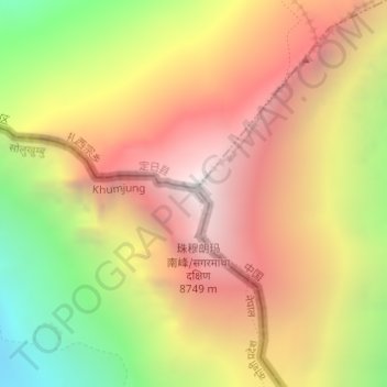
Name: Mount Everest topographic map, elevation, terrain.
Location: Mount Everest, Qutang, Tingri County, Shigatse, Tibet, China (27.98779 86.92478 27.98789 86.92488)
Average elevation: 7,839 m
Minimum elevation: 6,586 m
Maximum elevation: 8,849 m
Thank you for supporting this site ❤️
Make a donation
Make a donation