
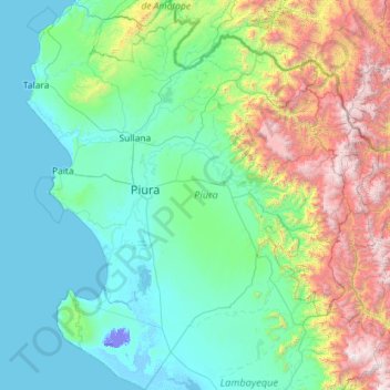
Piura topographic map
Interactive map
Click on the map to display elevation.
About this map
Name: Piura topographic map, elevation, terrain.
Location: Piura, Peru (-6.37209 -81.32823 -4.07933 -79.21033)
Average elevation: 675 m
Minimum elevation: -25 m
Maximum elevation: 4,013 m
Topography is smooth in the coast and rough in the Sierra. There are many arid plains in the southern region. The Sechura Desert, located south of the Piura River, is Peru's largest desert and one of the world's few examples of a tropical desert; it borders a tropical terrain to the north. The Bayóvar Depression, which is the lowest point in Peru and all of the Southern Tropics, is located in this desert.
Other topographic maps
Click on a map to view its topography, its elevation and its terrain.
Cienega
Peru > La Libertad > Patáz > Pataz
Cienega, Pataz, Patáz, Province of Pataz, La Libertad, Peru
Average elevation: 3,092 m
Province of San Marcos
Province of San Marcos, Cajamarca, 06321, Peru
Average elevation: 2,783 m
Province of Lima
Peru > Lima > Lima Metropolitan Area
Province of Lima, Lima Metropolitan Area, Lima, Peru
Average elevation: 1,234 m
Santa Fe
Peru > Loreto > Emilio San Martín
Santa Fe, Emilio San Martín, Province of Requena, Loreto, Peru
Average elevation: 103 m
Villa El Salvador
Peru > Lima > Villa El Salvador
Villa El Salvador, Province of Lima, Lima, Peru
Average elevation: 104 m
Laguna Palococha
Laguna Palococha, AN-110, Ticapampa, Province of Recuay, Ancash, Peru
Average elevation: 3,765 m
Villa El Salvador
Peru > Apurímac > Villa El Salvador
Villa El Salvador, Chincheros, Apurímac, Peru
Average elevation: 3,644 m
Río Tumbes
Peru > Tumbes > Pampas de Hospital
Río Tumbes, Pampas de Hospital, Province of Tumbes, Tumbes, Peru
Average elevation: 524 m
Province of Huaylas
Peru > Ancash > Santa Cruz
Province of Huaylas, Santa Cruz, Huaylas, Ancash, Peru
Average elevation: 2,353 m
Pueblo Libre
Peru > San Martín > Pueblo Libre
Pueblo Libre, Moyobamba, San Martín, Peru
Average elevation: 842 m
Ciudad Satélite
Peru > Junín > Ciudad Satélite
Ciudad Satélite, Province of Satipo, Junín, Peru
Average elevation: 768 m
Province of Chiclayo
Peru > Lambayeque > Pucalá
Province of Chiclayo, Pucalá, Chiclayo, Lambayeque, Peru
Average elevation: 348 m
San Martín de Porres
Peru > Lima > San Martín de Porres
San Martín de Porres, Province of Lima, Lima, Peru
Average elevation: 55 m
Laguna Palococha
Laguna Palococha, AN-110, Ticapampa, Recuay, Ancash, Peru
Average elevation: 3,765 m
Lauricocha
Peru > Huánuco > Lauricocha
Lauricocha, Province of Lauricocha, Huánuco, Peru
Average elevation: 4,002 m
Montevideo
Montevideo, Uranmarca, Province of Chincheros, Apurímac, Peru
Average elevation: 3,249 m
Zona Reservada Cordillera Huayhuash
Zona Reservada Cordillera Huayhuash, cutambo pass and siula grande view point, Cajatambo, Lima, Peru
Average elevation: 4,319 m
San Vicente de Cañete
Peru > Lima > San Vicente de Cañete
San Vicente de Cañete, Cañete, Lima, Peru
Average elevation: 85 m
Province of Carhuaz
Province of Carhuaz, Marcará, Carhuaz, Ancash, Peru
Average elevation: 3,217 m
Province of Caylloma
Province of Caylloma, Maca, Caylloma, Arequipa, Peru
Average elevation: 4,319 m