
Guayas topographic map
Interactive map
Click on the map to display elevation.
About this map
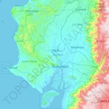
Name: Guayas topographic map, elevation, terrain.
Location: Guayas, Ecuador (-3.06426 -80.56330 -0.83665 -79.09809)
Average elevation: 519 m
Minimum elevation: -3 m
Maximum elevation: 4,464 m
Guayas' natural terrain is very diverse. The province has no elevations, except for the Coastal Range, which starts in Guayaquil and goes to Manabí. The areas west of the Coastal Range are desertic, with an average temperature of 23 °C. The areas east of the range belong to the Guayas Watershed. They are quite humid and fertile, especially in the north of the province, with an average temperature of 30 °C in the humid season (December–May) and 25 °C in the dry season (June–November).
Other topographic maps
Click on a map to view its topography, its elevation and its terrain.
Darwin
Ecuador > Galápagos > Cantón Isabela
Darwin, Parroquia Tomás de Berlanga (Santo Tomás), Cantón Isabela, Galápagos, Ecuador
Average elevation: 5 m
San Salvador
Ecuador > Galápagos > Cantón Santa Cruz
San Salvador, Cantón Santa Cruz, Galápagos, Ecuador
Average elevation: 81 m
Nevado Antisana
Nevado Antisana, Cuyuja, Cantón Quijos, Napo, Ecuador
Average elevation: 4,817 m
Isla Fernandina
Isla Fernandina, Cantón Isabela, Galápagos, Ecuador
Average elevation: 201 m
Carihuairazo
Ecuador > Tungurahua > Mocha
Carihuairazo, Mocha, Cantón Mocha, Tungurahua, Ecuador
Average elevation: 4,572 m
Valdivia
Ecuador > Santa Elena Province > Valdivia
Valdivia, Elena Canton, Santa Elena Province, Ecuador
Average elevation: 19 m
Buenos Aires
Ecuador > Santa Elena Province > Buenos Aires
Buenos Aires, Elena Canton, Santa Elena Province, Ecuador
Average elevation: 58 m