
Jiangxi topographic map
Interactive map
Click on the map to display elevation.
Jiangxi
The southern half of Jiangxi is hilly and mountainous, with ranges and valleys interspersed; notable mountains and mountain ranges include Mount Lu, the Jinggang Mountains and Mount Sanqing. The northern half is comparatively lower in altitude. The Gan River flows through the province.
About this map
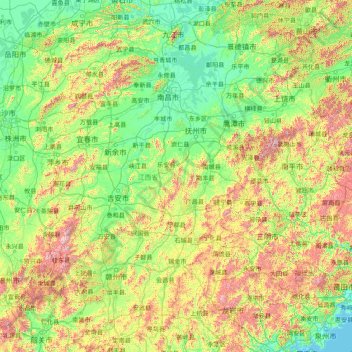
Name: Jiangxi topographic map, elevation, terrain.
Location: Jiangxi, China (24.48885 113.57490 30.07999 118.48216)
Average elevation: 327 m
Minimum elevation: -1 m
Maximum elevation: 2,037 m
Other topographic maps
Click on a map to view its topography, its elevation and its terrain.
Chongqing
The central urban area of Chongqing, or Chongqing proper, is a city of unique features. Built on mountains and partially surrounded by the Yangtze and Jialing rivers, it is known as a "mountain city" and a "city on rivers". The night scene of the city is very illuminated, with millions of lights and their…
Average elevation: 318 m
Beijing
Beijing is situated at the northern tip of the roughly triangular North China Plain, which opens to the south and east of the city. Mountains to the north, northwest and west shield the city and northern China's agricultural heartland from the encroaching desert steppes. The northwestern part of the…
Average elevation: 47 m
Mount Everest
China > Tibet > Qutang > Khumjung
Mount Everest (Chinese: 珠穆朗玛 Zhūmùlǎngmǎ; Nepali: सगरमाथा Sagarmāthā; Tibetan: Chomolungma ཇོ་མོ་གླང་མ) is Earth's highest mountain above sea level, located in the Mahalangur Himal sub-range of the Himalayas. The China–Nepal border runs across its summit…
Average elevation: 7,839 m
Nanjing
There are mainly two types of soil in Nanjing: zonal soil and cultivated soil. The zonal soil is yellow-brown soil in the northern and central areas of Nanjing, and red soil in the southern part of the border with Anhui. The cultivated soil formed by man-made farming is mainly paddy soil, and there are some…
Average elevation: 25 m
Huangshan
China > Anhui > Huangshan District
The vegetation of the area varies with elevation. Mesic forests cover the landscape below 1,100 meters. Deciduous forest stretches from 1,100 meters up to the tree line at 1,800 meters. Above that point, the vegetation consists of alpine grasslands. The area has diverse flora, where one-third of China's…
Average elevation: 754 m