
Vorarlberg topographic map
Interactive map
Click on the map to display elevation.
About this map
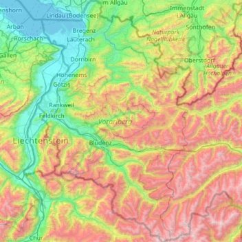
Name: Vorarlberg topographic map, elevation, terrain.
Location: Vorarlberg, Austria (46.84086 9.53075 47.59610 10.23716)
Average elevation: 1,382 m
Minimum elevation: 392 m
Maximum elevation: 3,386 m
The highest mountain is the Piz Buin, whose rocky peak of 3,312 m (10,866 ft) is surrounded by glaciers. The distance from Lake Constance and the plains of the Alpine Rhine valley across the medium altitude and high Alpine zones to the glaciers of the Silvretta range is a mere 90 km (56 mi).
Other topographic maps
Click on a map to view its topography, its elevation and its terrain.
KG Leopoldstadt
KG Leopoldstadt, Leopoldstadt, Vienna, 1020, Austria
Average elevation: 171 m
Flatschach
Austria > Styria > Bezirk Murtal > Flatschach
Flatschach, Spielberg, Bezirk Murtal, Styria, 8720, Austria
Average elevation: 751 m
Schlins
Austria > Vorarlberg > Schlins
Schlins, Feldkirch, Vorarlberg, 6824, Austria
Average elevation: 558 m
Hainfeld
Austria > Lower Austria > Hainfeld
Hainfeld, Bezirk Lilienfeld, Lower Austria, 3170, Austria
Average elevation: 577 m
Feldkirchen bei Graz
Austria > Styria > Feldkirchen bei Graz
Feldkirchen bei Graz, Graz-Umgebung, Styria, 8073, Austria
Average elevation: 335 m
Lake Neusiedl
Austria > Burgenland > Rust
Lake Neusiedl, Ruster Bucht, Rust, Burgenland, 7071, Austria
Average elevation: 147 m
Lechtal Alps
Lechtal Alps, Pfafflar, Reutte (Außerfern), Tyrol, Austria
Average elevation: 1,616 m
Großglockner
Austria > Carinthia > Heiligenblut am Großglockner
Großglockner, Heiligenblut am Großglockner, Spittal an der Drau, Carinthia, Austria
Average elevation: 3,128 m
Ötztal Alps
Ötztal Alps, Vernagthütte Guslarspitzen, Sölden, Imst, Tyrol, 6458, Austria
Average elevation: 2,098 m
Niedere Tauern
Niedere Tauern, Sölk, Gröbming, Liezen, Styria, Austria
Average elevation: 1,207 m
Ankogel Group
Ankogel Group, Malta, Spittal an der Drau, Carinthia, 9854, Austria
Average elevation: 1,683 m
Wildspitze
Wildspitze, Sölden, Imst, Tyrol, 6458, Austria
Average elevation: 3,284 m
Stuckkogel
Stuckkogel, Kitzbühel, Tyrol, 6371, Austria
Average elevation: 1,558 m
Verwall Alps
Austria > Vorarlberg > Silbertal
Verwall Alps, Silbertal, Bludenz, Vorarlberg, Austria
Average elevation: 1,957 m
Plechý / Plöckenstein
Austria > Upper Austria > Schwarzenberg am Böhmerwald
Plechý / Plöckenstein, Schwarzenberg am Böhmerwald, Rohrbach, Upper Austria, 4164, Austria
Average elevation: 1,196 m