Innsbruck topographic map
Interactive map
Click on the map to display elevation.
About this map
![Innsbruck topographic map, elevation, terrain](/pub/maps/relation/bw57/s2lftp/thumbnail.jpg)
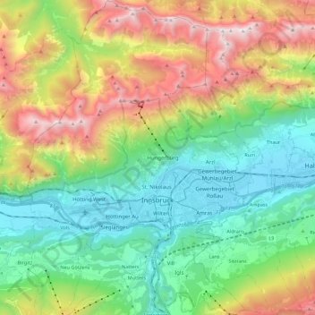
Name: Innsbruck topographic map, elevation, terrain.
Location: Innsbruck, Tyrol, Austria (47.21077 11.30164 47.36013 11.45596)
Average elevation: 1,280 m
Minimum elevation: 558 m
Maximum elevation: 2,668 m
Other topographic maps
Click on a map to view its topography, its elevation and its terrain.
![Lechtal Alps topographic map, elevation, terrain](/pub/maps/relation/m6gt/x74z5k/icon.jpg)
Lechtal Alps
Lechtal Alps, Pfafflar, Reutte (Außerfern), Tyrol, Austria
Average elevation: 1,616 m
![Ötztal Alps topographic map, elevation, terrain](/pub/maps/relation/h3cz/rqnn3q/icon.jpg)
Ötztal Alps
Ötztal Alps, Vernagthütte Guslarspitzen, Sölden, Imst, Tyrol, 6458, Austria
Average elevation: 2,098 m
![Wildspitze topographic map, elevation, terrain](/pub/maps/node/5w5k/s98q9f3/icon.jpg)
Wildspitze
Wildspitze, Sölden, Imst, Tyrol, 6458, Austria
Average elevation: 3,284 m
![Stuckkogel topographic map, elevation, terrain](/pub/maps/node/kkt6/d2wt8btf/icon.jpg)
Stuckkogel
Stuckkogel, Kitzbühel, Tyrol, 6371, Austria
Average elevation: 1,558 m