
Mount Aspiring topographic map
Interactive map
Click on the map to display elevation.
About this map
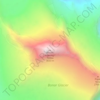
Name: Mount Aspiring topographic map, elevation, terrain.
Location: Mount Aspiring, Westland District, West Coast, New Zealand (-44.38421 168.72791 -44.38411 168.72801)
Average elevation: 2,257 m
Minimum elevation: 1,635 m
Maximum elevation: 2,991 m
Other topographic maps
Click on a map to view its topography, its elevation and its terrain.
Wellington
New Zealand > Wellington > Wellington City
Wellington, Wellington City, Wellington, 6011, New Zealand
Average elevation: 85 m
St. Arnaud
New Zealand > Tasman > St. Arnaud
St. Arnaud, Tasman, 7072, New Zealand
Average elevation: 701 m
Chatham Islands
Chatham Islands, Kaiwhata Road, Kaingaroa, Chatham Islands, 8942, New Zealand
Average elevation: 7 m
South Wairarapa District
South Wairarapa District, Wellington, New Zealand
Average elevation: 189 m
Milford Sound
Milford Sound, Southland District, Southland, New Zealand
Average elevation: 304 m
Whitianga
New Zealand > Waikato > Whitianga
Whitianga, Thames Coromandel District, Waikato, 3510, New Zealand
Average elevation: 43 m
Ball Glacier
Ball Glacier, Caroline hut to ball hut, Mackenzie District, Canterbury, New Zealand
Average elevation: 1,324 m
Gisborne Point
New Zealand > Bay of Plenty > Rotoiti > Gisborne Point
Gisborne Point, Rotoiti, Rotorua District, Bay of Plenty, 3074, New Zealand
Average elevation: 350 m
Pickelhaube Glacier
Pickelhaube Glacier, Westland District, West Coast, New Zealand
Average elevation: 1,836 m
Mount Ngāuruhoe
Mount Ngāuruhoe, Ruapehu District, Manawatu-Wanganui, New Zealand
Average elevation: 1,726 m
Bell Glacier
Bell Glacier, poled route only, Queenstown-Lakes District, Otago, New Zealand
Average elevation: 1,666 m
Dennistoun Glacier
Dennistoun Glacier, Mackenzie District, Canterbury, New Zealand
Average elevation: 2,026 m
Eugenie Glacier
New Zealand > Canterbury > Mount Cook Village
Eugenie Glacier, Hooker Valley Track, Mount Cook Village, Mackenzie District, Canterbury, 7946, New Zealand
Average elevation: 1,827 m
Mount Cook
Mount Cook, Mackenzie District, Canterbury, New Zealand
Average elevation: 2,920 m
Mount Hutt
Mount Hutt, Ashburton District, Canterbury, New Zealand
Average elevation: 1,732 m
Mount Ruapehu
Mount Ruapehu, Ruapehu District, Manawatu-Wanganui, New Zealand
Average elevation: 2,439 m
Mount Tasman
Mount Tasman, Westland District, West Coast, New Zealand
Average elevation: 2,798 m
Cerberus
Cerberus, Queenstown-Lakes District, Otago, New Zealand
Average elevation: 1,819 m
Napier
Napier, Napier City, Hawke's Bay, 4001, New Zealand
Average elevation: 33 m
Christchurch City
Christchurch City, Canterbury, New Zealand
Average elevation: 74 m
Aida Glacier
Aida Glacier, Mackenzie District, Canterbury, New Zealand
Average elevation: 1,999 m
Rakiura National Park
Rakiura National Park, Southern Circuit Track, Southland, New Zealand
Average elevation: 63 m
Donald Glacier
Donald Glacier, Westland District, West Coast, New Zealand
Average elevation: 1,865 m
David Glacier
David Glacier, Brewster Track, Westland District, West Coast, New Zealand
Average elevation: 1,648 m
Southern Alps
Southern Alps, Mackenzie District, Canterbury, New Zealand
Average elevation: 2,832 m
Mount Taranaki
Mount Taranaki, Stratford District, Taranaki, 4642, New Zealand
Average elevation: 1,847 m
Bonar Glacier
Bonar Glacier, Westland District, West Coast, New Zealand
Average elevation: 1,916 m
Te Hīwai / Murchison Glacier
Te Hīwai / Murchison Glacier, Mackenzie District, Canterbury, New Zealand
Average elevation: 1,875 m
Arthur Glacier
Arthur Glacier, Westland District, West Coast, New Zealand
Average elevation: 1,656 m
South Island
South Island, Mackenzie District, Canterbury, New Zealand
Average elevation: 201 m
Tasman Glacier
Tasman Glacier, Caroline hut to ball hut, Mackenzie District, Canterbury, New Zealand
Average elevation: 1,781 m
Frances Glacier
Frances Glacier, Rees-Dart Track, Queenstown-Lakes District, Otago, New Zealand
Average elevation: 1,958 m
Stewart Island / Rakiura
Stewart Island / Rakiura, Southland, New Zealand
Average elevation: 63 m
Franz Josef
Franz Josef, Westland District, West Coast, 7856, New Zealand
Average elevation: 277 m
Mount Tongariro
Mount Tongariro, Ruapehu District, Manawatu-Wanganui, New Zealand
Average elevation: 1,675 m
Mount Stewart
Mount Stewart, Manawatu District, Manawatu-Wanganui, New Zealand
Average elevation: 103 m
Cascade Glacier
Cascade Glacier, Mackenzie District, Canterbury, New Zealand
Average elevation: 2,106 m