Auckland topographic map
Interactive map
Click on the map to display elevation.
About this map
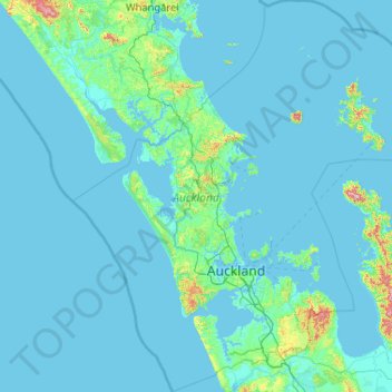
Name: Auckland topographic map, elevation, terrain.
Location: Auckland, New Zealand (-37.36447 173.89633 -35.69839 175.90322)
Average elevation: 30 m
Minimum elevation: -1 m
Maximum elevation: 836 m
The Auckland Volcanic Field has contributed greatly to the growth and prosperity of the Auckland Region since the area was settled by humans. Initially, the maunga (scoria cones) were occupied and established as pā (fortified settlements) by Māori due to the strategic advantage their elevation provided in controlling resources and key portages between the Waitematā and Manukau harbours. The rich volcanic soils found in these areas also proved ideal for the cultivation of crops, such as kūmara. Following European arrival, many of the maunga were transformed into quarries to supply the growing city with aggregate and building materials, and as a result were severely damaged or entirely destroyed. A number of the smaller maar craters and tuff rings were also removed during earthworks. Most of the remaining volcanic centres are now preserved within recreational reserves administered by Auckland Council, the Department of Conservation, and the Tūpuna Maunga o Tāmaki Makaurau Authority.
Other topographic maps
Click on a map to view its topography, its elevation and its terrain.
Wellington
New Zealand > Wellington > Wellington City
Wellington, Wellington City, Wellington, 6011, New Zealand
Average elevation: 85 m
St. Arnaud
New Zealand > Tasman > St. Arnaud
St. Arnaud, Tasman, 7072, New Zealand
Average elevation: 701 m
Chatham Islands
Chatham Islands, Kaiwhata Road, Kaingaroa, Chatham Islands, 8942, New Zealand
Average elevation: 7 m
South Wairarapa District
South Wairarapa District, Wellington, New Zealand
Average elevation: 189 m
Milford Sound
Milford Sound, Southland District, Southland, New Zealand
Average elevation: 304 m
Whitianga
New Zealand > Waikato > Whitianga
Whitianga, Thames Coromandel District, Waikato, 3510, New Zealand
Average elevation: 43 m
Ball Glacier
Ball Glacier, Caroline hut to ball hut, Mackenzie District, Canterbury, New Zealand
Average elevation: 1,324 m
Gisborne Point
New Zealand > Bay of Plenty > Rotoiti > Gisborne Point
Gisborne Point, Rotoiti, Rotorua District, Bay of Plenty, 3074, New Zealand
Average elevation: 350 m
Pickelhaube Glacier
Pickelhaube Glacier, Westland District, West Coast, New Zealand
Average elevation: 1,836 m
Mount Ngāuruhoe
Mount Ngāuruhoe, Ruapehu District, Manawatu-Wanganui, New Zealand
Average elevation: 1,726 m
Bell Glacier
Bell Glacier, poled route only, Queenstown-Lakes District, Otago, New Zealand
Average elevation: 1,666 m
Dennistoun Glacier
Dennistoun Glacier, Mackenzie District, Canterbury, New Zealand
Average elevation: 2,026 m
Eugenie Glacier
New Zealand > Canterbury > Mount Cook Village
Eugenie Glacier, Hooker Valley Track, Mount Cook Village, Mackenzie District, Canterbury, 7946, New Zealand
Average elevation: 1,827 m
Mount Cook
Mount Cook, Mackenzie District, Canterbury, New Zealand
Average elevation: 2,920 m
Mount Hutt
Mount Hutt, Ashburton District, Canterbury, New Zealand
Average elevation: 1,732 m
Mount Ruapehu
Mount Ruapehu, Ruapehu District, Manawatu-Wanganui, New Zealand
Average elevation: 2,439 m
Mount Tasman
Mount Tasman, Westland District, West Coast, New Zealand
Average elevation: 2,798 m
Cerberus
Cerberus, Queenstown-Lakes District, Otago, New Zealand
Average elevation: 1,819 m
Napier
Napier, Napier City, Hawke's Bay, 4001, New Zealand
Average elevation: 33 m
Christchurch City
Christchurch City, Canterbury, New Zealand
Average elevation: 74 m
Aida Glacier
Aida Glacier, Mackenzie District, Canterbury, New Zealand
Average elevation: 1,999 m
Rakiura National Park
Rakiura National Park, Southern Circuit Track, Southland, New Zealand
Average elevation: 63 m
Donald Glacier
Donald Glacier, Westland District, West Coast, New Zealand
Average elevation: 1,865 m
David Glacier
David Glacier, Brewster Track, Westland District, West Coast, New Zealand
Average elevation: 1,648 m
Southern Alps
Southern Alps, Mackenzie District, Canterbury, New Zealand
Average elevation: 2,832 m
Mount Taranaki
Mount Taranaki, Stratford District, Taranaki, 4642, New Zealand
Average elevation: 1,847 m
Bonar Glacier
Bonar Glacier, Westland District, West Coast, New Zealand
Average elevation: 1,916 m
Te Hīwai / Murchison Glacier
Te Hīwai / Murchison Glacier, Mackenzie District, Canterbury, New Zealand
Average elevation: 1,875 m
Mount Aspiring
Mount Aspiring, Westland District, West Coast, New Zealand
Average elevation: 2,257 m
Arthur Glacier
Arthur Glacier, Westland District, West Coast, New Zealand
Average elevation: 1,656 m
South Island
South Island, Mackenzie District, Canterbury, New Zealand
Average elevation: 201 m
Tasman Glacier
Tasman Glacier, Caroline hut to ball hut, Mackenzie District, Canterbury, New Zealand
Average elevation: 1,781 m
Frances Glacier
Frances Glacier, Rees-Dart Track, Queenstown-Lakes District, Otago, New Zealand
Average elevation: 1,958 m
Stewart Island / Rakiura
Stewart Island / Rakiura, Southland, New Zealand
Average elevation: 63 m
Franz Josef
Franz Josef, Westland District, West Coast, 7856, New Zealand
Average elevation: 277 m
Mount Tongariro
Mount Tongariro, Ruapehu District, Manawatu-Wanganui, New Zealand
Average elevation: 1,675 m
Mount Stewart
Mount Stewart, Manawatu District, Manawatu-Wanganui, New Zealand
Average elevation: 103 m
Cascade Glacier
Cascade Glacier, Mackenzie District, Canterbury, New Zealand
Average elevation: 2,106 m