
Manawatū-Whanganui topographic map
Interactive map
Click on the map to display elevation.
About this map
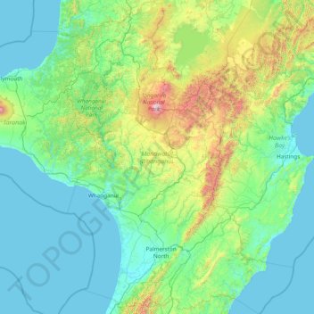
Name: Manawatū-Whanganui topographic map, elevation, terrain.
Location: Manawatū-Whanganui, New Zealand (-40.81095 174.67517 -38.47033 176.89427)
Average elevation: 306 m
Minimum elevation: 0 m
Maximum elevation: 2,717 m
The area includes a variety of landscape formations. Districts close to the Volcanic Plateau are higher and more rugged, often subject to harsh temperatures in winter. The Manawatū District has a much gentler topography, consisting mainly of the flat, tree-studded Manawatū Plains that run between the ranges and the sea. The land was under the sea till about 500,000 years ago and still has a very thick layer of marine sediment, which is about five or six million years old. A block faulting system underneath the thick sediment has raised a series of domes and gentle depressions. These structures can provide natural storage areas for oil and some of the Manawatu domes have been drilled. The domes have shaped the course of the Manawatū River, giving it a meandering path which, uniquely among New Zealand rivers, begins close to the east coast and exits on the west coast. The Manawatū River begins just inside the Hawke's Bay Region, then flows through a deep gorge to the Manawatu Plains before exiting in the Tasman Sea. The river is also unique in New Zealand (and rare worldwide) in that this gorge (the Manawatū Gorge) is a water gap through recently uplifted rock, causing the river to flow from relatively low-lying land along an eroded course through higher terrain. The Whanganui District is more rugged, with canyon-like valleys and gorges carved out of the soft rock by rivers and ocean waves.
Other topographic maps
Click on a map to view its topography, its elevation and its terrain.
Wellington
New Zealand > Wellington > Wellington City
Wellington, Wellington City, Wellington, 6011, New Zealand
Average elevation: 85 m
St. Arnaud
New Zealand > Tasman > St. Arnaud
St. Arnaud, Tasman, 7072, New Zealand
Average elevation: 701 m
Chatham Islands
Chatham Islands, Kaiwhata Road, Kaingaroa, Chatham Islands, 8942, New Zealand
Average elevation: 7 m
South Wairarapa District
South Wairarapa District, Wellington, New Zealand
Average elevation: 189 m
Milford Sound
Milford Sound, Southland District, Southland, New Zealand
Average elevation: 304 m
Whitianga
New Zealand > Waikato > Whitianga
Whitianga, Thames Coromandel District, Waikato, 3510, New Zealand
Average elevation: 43 m
Ball Glacier
Ball Glacier, Caroline hut to ball hut, Mackenzie District, Canterbury, New Zealand
Average elevation: 1,324 m
Gisborne Point
New Zealand > Bay of Plenty > Rotoiti > Gisborne Point
Gisborne Point, Rotoiti, Rotorua District, Bay of Plenty, 3074, New Zealand
Average elevation: 350 m
Pickelhaube Glacier
Pickelhaube Glacier, Westland District, West Coast, New Zealand
Average elevation: 1,836 m
Mount Ngāuruhoe
Mount Ngāuruhoe, Ruapehu District, Manawatu-Wanganui, New Zealand
Average elevation: 1,726 m
Bell Glacier
Bell Glacier, poled route only, Queenstown-Lakes District, Otago, New Zealand
Average elevation: 1,666 m
Dennistoun Glacier
Dennistoun Glacier, Mackenzie District, Canterbury, New Zealand
Average elevation: 2,026 m
Eugenie Glacier
New Zealand > Canterbury > Mount Cook Village
Eugenie Glacier, Hooker Valley Track, Mount Cook Village, Mackenzie District, Canterbury, 7946, New Zealand
Average elevation: 1,827 m
Mount Cook
Mount Cook, Mackenzie District, Canterbury, New Zealand
Average elevation: 2,920 m
Mount Hutt
Mount Hutt, Ashburton District, Canterbury, New Zealand
Average elevation: 1,732 m
Mount Ruapehu
Mount Ruapehu, Ruapehu District, Manawatu-Wanganui, New Zealand
Average elevation: 2,439 m
Mount Tasman
Mount Tasman, Westland District, West Coast, New Zealand
Average elevation: 2,798 m
Cerberus
Cerberus, Queenstown-Lakes District, Otago, New Zealand
Average elevation: 1,819 m
Napier
Napier, Napier City, Hawke's Bay, 4001, New Zealand
Average elevation: 33 m
Christchurch City
Christchurch City, Canterbury, New Zealand
Average elevation: 74 m
Aida Glacier
Aida Glacier, Mackenzie District, Canterbury, New Zealand
Average elevation: 1,999 m
Rakiura National Park
Rakiura National Park, Southern Circuit Track, Southland, New Zealand
Average elevation: 63 m
Donald Glacier
Donald Glacier, Westland District, West Coast, New Zealand
Average elevation: 1,865 m
David Glacier
David Glacier, Brewster Track, Westland District, West Coast, New Zealand
Average elevation: 1,648 m
Southern Alps
Southern Alps, Mackenzie District, Canterbury, New Zealand
Average elevation: 2,832 m
Mount Taranaki
Mount Taranaki, Stratford District, Taranaki, 4642, New Zealand
Average elevation: 1,847 m
Bonar Glacier
Bonar Glacier, Westland District, West Coast, New Zealand
Average elevation: 1,916 m
Te Hīwai / Murchison Glacier
Te Hīwai / Murchison Glacier, Mackenzie District, Canterbury, New Zealand
Average elevation: 1,875 m
Mount Aspiring
Mount Aspiring, Westland District, West Coast, New Zealand
Average elevation: 2,257 m
Arthur Glacier
Arthur Glacier, Westland District, West Coast, New Zealand
Average elevation: 1,656 m
South Island
South Island, Mackenzie District, Canterbury, New Zealand
Average elevation: 201 m
Tasman Glacier
Tasman Glacier, Caroline hut to ball hut, Mackenzie District, Canterbury, New Zealand
Average elevation: 1,781 m
Frances Glacier
Frances Glacier, Rees-Dart Track, Queenstown-Lakes District, Otago, New Zealand
Average elevation: 1,958 m
Stewart Island / Rakiura
Stewart Island / Rakiura, Southland, New Zealand
Average elevation: 63 m
Franz Josef
Franz Josef, Westland District, West Coast, 7856, New Zealand
Average elevation: 277 m
Mount Tongariro
Mount Tongariro, Ruapehu District, Manawatu-Wanganui, New Zealand
Average elevation: 1,675 m
Mount Stewart
Mount Stewart, Manawatu District, Manawatu-Wanganui, New Zealand
Average elevation: 103 m
Cascade Glacier
Cascade Glacier, Mackenzie District, Canterbury, New Zealand
Average elevation: 2,106 m